
ファイル:Map of Europe (political).png
このプレビューのサイズ: 800 × 523 ピクセル。 その他の解像度: 320 × 209 ピクセル | 640 × 418 ピクセル | 1,024 × 669 ピクセル | 1,280 × 836 ピクセル | 1,596 × 1,043 ピクセル。
元のファイル (1,596 × 1,043 ピクセル、ファイルサイズ: 86キロバイト、MIME タイプ: image/png)
ウィキメディア・コモンズのファイルページにある説明を、以下に表示します。
|
.png?uselang=ja)
.png?uselang=ja)
.png?uselang=ja&action=history)
.png)

|
This map has been uploaded by Electionworld from en.wikipedia.org to enable the |
概要
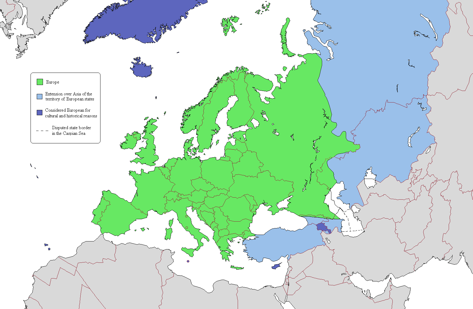
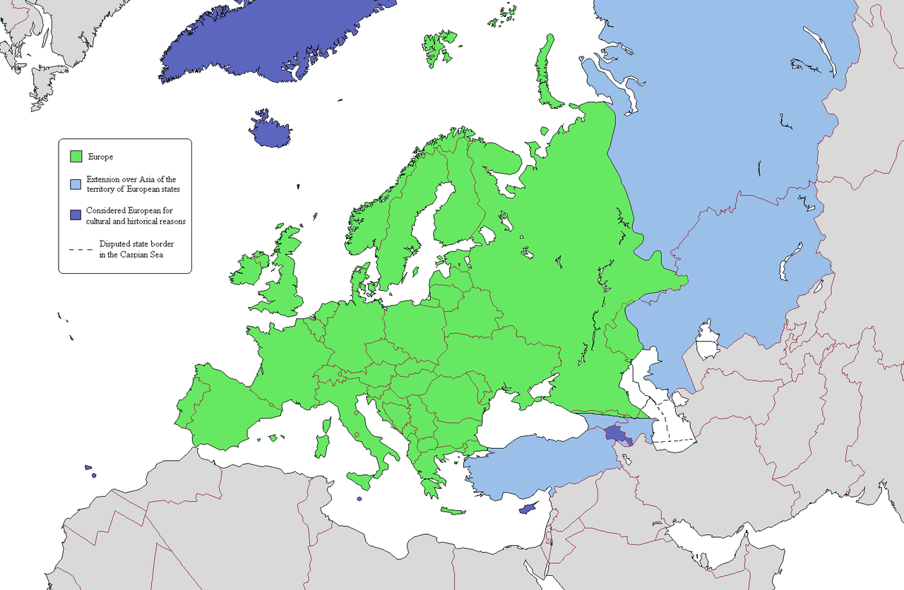
This is a map intended to show the continental boundary of Europe, and the territory of transcontinental states. The map is flawed in a number of ways, and a corrected version is found at [[: File:Europe Asia transcontinental.png]]. Since the latter is a derived version of this one, a copy of the flawed map should be kept around for licencing reasons. The original map appears to have been uploaded to Wikipedia in 2006 by en:User:Alinor.
このファイルの派生的著作物: Europe Asia transcontinental.png
このファイルの派生的著作物: Map of Europe 2007 (political) de.png
_de.png)

|
この地図画像は、ベクターイメージである SVG ファイルとして再作成されるべきです。これにはいくつかの利点があります。詳しくはCommons:Media for cleanupを参照してください。この画像の SVG 形式がすでに利用可能である場合は、アップロードしてください。アップロード後、この画像にあるこのテンプレートを{{Vector version available|新しい画像ファイル名.svg}}テンプレートで置き換えてください。
|
ライセンス
この作品の著作権者である私は、この作品を以下のライセンスで提供します。

|
この文書は、フリーソフトウェア財団発行のGNUフリー文書利用許諾書 (GNU Free Documentation License) 1.2またはそれ以降のバージョンの規約に基づき、複製や再配布、改変が許可されます。不可変更部分、表紙、背表紙はありません。このライセンスの複製は、GNUフリー文書利用許諾書という章に含まれています。 |
| このファイルはクリエイティブ・コモンズ 表示-継承 3.0 非移植ライセンスのもとに利用を許諾されています。 | ||
| ||
| このライセンスのテンプレートは、GFDLのライセンス・アップデートによりこのファイルに追加されたものです。 |
あなたは上記のライセンスから、どれか一つ以上を選択できます。
ファイルの履歴
過去の版のファイルを表示するには、その版の日時をクリックしてください。
.png&dir=prev)
.png&offset=20110409134150)
.png&offset=&limit=20)
.png&offset=&limit=50)
.png&offset=&limit=100)
.png&offset=&limit=250)
.png&offset=&limit=500)
| 日付と時刻 | サムネイル | 寸法 | 利用者 | コメント | |
|---|---|---|---|---|---|
| 現在の版 | 2019年6月20日 (木) 22:03 | | 1,596 × 1,043 (86キロバイト) | Rs4815 | Border in the south-east passes along the Greater Caucasus Range |
| 2011年4月16日 (土) 04:05 |  | 1,596 × 1,043 (107キロバイト) | Wsiegmund | Reverted to version as of 19:16, 13 November 2009; see http://commons.wikimedia.org/w/index.php?title=User_talk:Wsiegmund&oldid=53219388#File:Map_of_Europe_.28political.29.png | |
| 2011年4月13日 (水) 03:28 |  | 1,596 × 1,043 (71キロバイト) | Green, White and Gold | Reverted to Dbachmann's version as of 11:49, 8 April 2011 | |
| 2011年4月13日 (水) 02:37 |  | 1,596 × 1,043 (71キロバイト) | Gerge | Reverted to version as of 06:06, 12 April 2011 | |
| 2011年4月12日 (火) 23:12 |  | 1,596 × 1,043 (71キロバイト) | Green, White and Gold | Reverted to Dbachmann's version as of 11:49, 8 April 2011 | |
| 2011年4月12日 (火) 23:09 |  | 1,596 × 1,043 (107キロバイト) | Green, White and Gold | Reverted to Dbachmann's version as of 13:41, 9 April 2011 | |
| 2011年4月12日 (火) 06:06 |  | 1,596 × 1,043 (71キロバイト) | Sigismun | Reverted to version as of 19:54, 10 April 2011 | |
| 2011年4月12日 (火) 01:06 |  | 1,596 × 1,043 (107キロバイト) | Green, White and Gold | Reverted to Dbachmann's version as of 13:41, 9 April 2011 | |
| 2011年4月10日 (日) 19:54 |  | 1,596 × 1,043 (71キロバイト) | ComtesseDeMingrelie | rv. per Commons:Avoid overwriting existing files | |
| 2011年4月9日 (土) 13:41 |  | 1,596 × 1,043 (107キロバイト) | Dbachmann | so, since this map is going to be useless anyway, rv to 3 February 2009 per "Commons:Avoid overwriting existing files." |
ファイルの使用状況
このファイルを使用しているページはありません。
グローバルなファイル使用状況
以下に挙げる他のウィキがこの画像を使っています:
- cs.wikipedia.org での使用状況
- da.wikipedia.org での使用状況
- de.wikipedia.org での使用状況
- en.wikipedia.org での使用状況
- User:Rashed
- User:Siyavash
- User:Kenzilla
- User:Australian Jezza
- Template:User Eurasian
- User:WiKID Daryl
- User:Royaljared
- User:Angelo De La Paz
- User:PinkPanthress
- Talk:Georgia/Archive 1
- User:Finlandlover
- User talk:BadYodels
- User:Tweisbach
- User:Obaidz96/UBX
- User:Czar Choi
- User:Lenoxus/Subpages/Public/Old
- User:Masumisyan
- User:PKLion
- User:Sweet & Sour Grapes
- User:Shakarian141
- User:Niceguy90
- User:Epileptic Mushroom
- Talk:Armenia/Archive 5
- User:Alexander Rudik
- User:Kunayev
- User:Bush111
- Wikipedia:Graphics Lab/Map workshop/Archive/Apr 2010
- Template talk:Passports/Archive 1
- User:Bgh1111
- User:Lukex115
- User:Lukex115/Userboxen
- User:RussLover
- User:Jextredo
- User:Azndrumsticks
- User:Katangais/Travel
- Wikipedia:Userboxes/Life/Ethnicity
- User:Slawful Justice
- User:Weidorje
- User:Alfredcranham
- User:Chinggis6/Tengerid Traits
- es.wikipedia.org での使用状況
- fr.wikipedia.org での使用状況
- it.wikipedia.org での使用状況
- ko.wikipedia.org での使用状況
- mk.wikipedia.org での使用状況
- pl.wikipedia.org での使用状況
このファイルのグローバル使用状況を表示する。
.png)
.png)