
ファイル:Mali.A2001291.1045.250m.jpg

このプレビューのサイズ: 800 × 600 ピクセル。 その他の解像度: 320 × 240 ピクセル | 640 × 480 ピクセル | 1,024 × 768 ピクセル | 1,280 × 960 ピクセル | 2,560 × 1,920 ピクセル | 4,000 × 3,000 ピクセル。
元のファイル (4,000 × 3,000 ピクセル、ファイルサイズ: 1.75メガバイト、MIME タイプ: image/jpeg)
ウィキメディア・コモンズのファイルページにある説明を、以下に表示します。
|
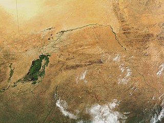
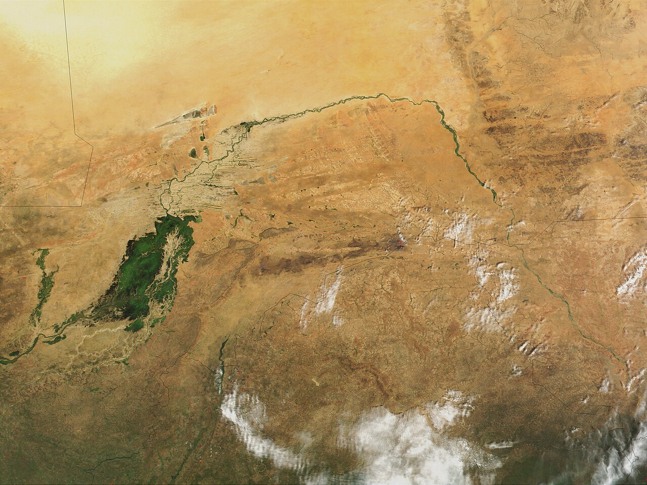
| 解説 | Niger River in Mali, 2001. Just south of the Sahara Desert in Africa, the Niger River creates a lush area of wetlands and lakes in an otherwise arid environment. In this true-color MODIS image from October 18, 2001, the Niger enters at left as a thin strip of green and flows northeast through Mali. The river then turns south and heads into the country of Niger. (Note, this is at the end of the rainy season, showing the Niger Inland Delta in dark green). | |||||
| 日付 |
Visualization Date 2001-10-18 |
|||||
| 原典 | http://veimages.gsfc.nasa.gov/2243/Mali.A2001291.1045.250m.jpg | |||||
| 作者 | Jacques Descloitres, MODIS Land Rapid Response Team, NASA/GSFC | |||||
| 許可 (ファイルの再利用) |
PD, US Gov
|

ファイルの履歴
過去の版のファイルを表示するには、その版の日時をクリックしてください。
| 日付と時刻 | サムネイル | 寸法 | 利用者 | コメント | |
|---|---|---|---|---|---|
| 現在の版 | 2008年3月8日 (土) 22:43 | | 4,000 × 3,000 (1.75メガバイト) | T L Miles | {{Information |Description=Niger River in Mali, 2001. Just south of the Sahara Desert in Africa, the Niger River creates a lush area of wetlands and lakes in an otherwise arid environment. In this true-color MODIS image from October 18, 2001, the Niger en |
ファイルの使用状況
以下のページがこのファイルを使用しています:
グローバルなファイル使用状況
以下に挙げる他のウィキがこの画像を使っています:
- af.wikipedia.org での使用状況
- as.wikipedia.org での使用状況
- bg.wikipedia.org での使用状況
- ca.wikipedia.org での使用状況
- cy.wikipedia.org での使用状況
- en.wikipedia.org での使用状況
- eo.wikipedia.org での使用状況
- fr.wikipedia.org での使用状況
- ilo.wikipedia.org での使用状況
- la.wikipedia.org での使用状況
- no.wikipedia.org での使用状況
- oc.wikipedia.org での使用状況
- pt.wikipedia.org での使用状況
- sr.wikipedia.org での使用状況
- sv.wikipedia.org での使用状況
- sw.wikipedia.org での使用状況
- ta.wikipedia.org での使用状況
- uk.wikipedia.org での使用状況
- zh.wikipedia.org での使用状況