
ファイル:MGS MOC Wide Angle Map of Mars PIA03467.jpg

元のファイル (2,000 × 1,288 ピクセル、ファイルサイズ: 534キロバイト、MIME タイプ: image/jpeg)
ウィキメディア・コモンズのファイルページにある説明を、以下に表示します。
|
概要
| 解説 |
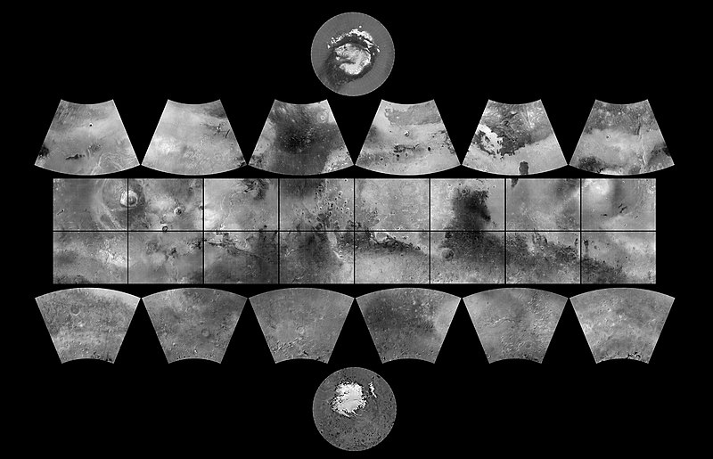
English: The MGS MOC Wide Angle Map of Mars
In 1979, NASA published ATLAS OF MARS: THE 1:5,000,000 MAP SERIES, edited by R.M. Batson, P.M. Bridges, and J.L. Inge, of the U.S. Geological Survey in Flagstaff, Arizona. This was a compendium of airbrushed shaded relief maps, controlled photomosaics, and in a few cases albedo (shading) maps, mostly assembled from Mariner 9 survey images, with some gaps filled by Viking orbiter images. The planet was divided into thirty "quadrangles" or areas, each with an "Mars Chart" or "MC" number (MC-1 through MC-30). The equatorial region was portrayed in the Mercator projection, with Lambert Conformal Conic for the mid-latitudes and Polar Stereographic for the poles. Although digital products such as the Mars Digital Image Mosaic (MDIM) and various Mars Global Surveyor (MGS) Mars Orbiter Laser Altimeter (MOLA) maps have partially supplanted the ATLAS, it remains a standard desktop reference today. In 1999, the Mars Orbiter Camera (MOC) aboard the MGS orbiter acquired a global stereo image dataset using its red-filter Wide Angle Camera. We have recently completed a 256 pixel/degree (about 230 meters/pixel) mosaic of these images using software developed at Malin Space Science Systems(MSSS). Visit the MSSS Geodesy Campaign Mosaic Page to access both partial and full-resolution mosaics in Planetary Data System format. The image above is a reproduction of the new MGS MOC Mars Digital Map and is the first of several cartographic products that MSSS expects to release this year. Malin Space Science Systems and the California Institute of Technology built the MOC using spare hardware from the Mars Observer mission. MSSS operates the camera from its facilities in San Diego, CA. The Jet Propulsion Laboratory's Mars Surveyor Operations Project operates the Mars Global Surveyor spacecraft with its industrial partner, Lockheed Martin Astronautics, from facilities in Pasadena, CA and Denver, CO. |
| 日付 | (addition date) |
| 原典 | http://photojournal.jpl.nasa.gov/catalog/PIA03467 (image link) |
| 作者 | NASA/JPL/MSSS |
| このタグは、添付された著作物の著作権状況を示すものではありません。通常の著作権タグも必要です。Commons:ライセンシングもご覧ください。 他言語での翻訳:
|
ライセンス
| このファイルはアメリカ航空宇宙局(NASA)によって作成されたものです。NASAの著作権の方針では、特記事項が無い場合、NASAの資料はパブリックドメインとなります。 (詳しくはTemplate:PD-USGov、NASAの著作権の方針について(英語)又はジェット推進研究所(JPL)の画像使用に関するガイドライン(英語)をご覧ください。) |
||
 |
注意事項:
|
| 注釈 | この画像には注釈がついています: コモンズで注釈を見る |
ファイルの履歴
過去の版のファイルを表示するには、その版の日時をクリックしてください。
| 日付と時刻 | サムネイル | 寸法 | 利用者 | コメント | |
|---|---|---|---|---|---|
| 現在の版 | 2019年2月18日 (月) 10:19 | | 2,000 × 1,288 (534キロバイト) | Kesäperuna | 100% JPEG quality from full quality TIFF. (Upload preceding this was 90% JPEG) |
| 2019年2月18日 (月) 09:54 |  | 2,000 × 1,288 (473キロバイト) | Kesäperuna | 100% JPEG quality from full quality TIFF. | |
| 2008年4月12日 (土) 07:27 |  | 2,000 × 1,288 (212キロバイト) | Bryan Derksen | {{Information |Description={{en|In 1999, the Mars Orbiter Camera (MOC) aboard the MGS orbiter acquired a global stereo image dataset using its red-filter Wide Angle Camera. We have recently completed a 256 pixel/degree (about 230 meters/pixel) mosaic of t |
ファイルの使用状況
以下のページがこのファイルを使用しています:
グローバルなファイル使用状況
以下に挙げる他のウィキがこの画像を使っています:
- ar.wikipedia.org での使用状況
- az.wikipedia.org での使用状況
- bs.wikipedia.org での使用状況
- ca.wikipedia.org での使用状況
- Exploració de Mart
- Cartografia de Mart
- Categoria:Quadrangles de Mart
- Categoria:Quadrangle Mare Boreum
- Categoria:Quadrangle Mare Acidalium
- Categoria:Quadrangle Diacria
- Categoria:Quadrangle Aeolis
- Categoria:Quadrangle Elysium
- Categoria:Quadrangle Ismenius Lacus
- Categoria:Quadrangle Cebrenia
- Categoria:Quadrangle Tharsis
- Categoria:Quadrangle Lunae Palus
- Categoria:Quadrangle Syrtis Major
- Categoria:Quadrangle Oxia Palus
- Categoria:Quadrangle Arabia
- Categoria:Quadrangle Amenthes
- Categoria:Quadrangle Memnonia
- Categoria:Quadrangle Phoenicis Lacus
- Categoria:Quadrangle Margaritifer Sinus
- Categoria:Quadrangle Sinus Sabaeus
- Categoria:Quadrangle Phaethontis
- Categoria:Quadrangle Thaumasia
- Categoria:Quadrangle Argyre
- Categoria:Quadrangle Noachis
- Categoria:Quadrangle Hellas
- Categoria:Quadrangle Mare Australe
- Categoria:Quadrangle Eridania
- Categoria:Quadrangle Arcadia
- Categoria:Quadrangle Casius
- Categoria:Quadrangle Coprates
- Categoria:Quadrangle Amazonis
- Plantilla:Quadrangles de Mart
- Categoria:Quadrangle Iapygia
- Categoria:Quadrangle Mare Tyrrhenum
- de.wikipedia.org での使用状況
このファイルのグローバル使用状況を表示する。