
ファイル:Jangmi 2008-09-27 0445Z.jpg

このプレビューのサイズ: 473 × 599 ピクセル。 その他の解像度: 189 × 240 ピクセル | 379 × 480 ピクセル | 606 × 768 ピクセル | 808 × 1,024 ピクセル | 1,617 × 2,048 ピクセル | 6,000 × 7,600 ピクセル。
元のファイル (6,000 × 7,600 ピクセル、ファイルサイズ: 4.93メガバイト、MIME タイプ: image/jpeg)
ウィキメディア・コモンズのファイルページにある説明を、以下に表示します。
|
概要
| 解説 |
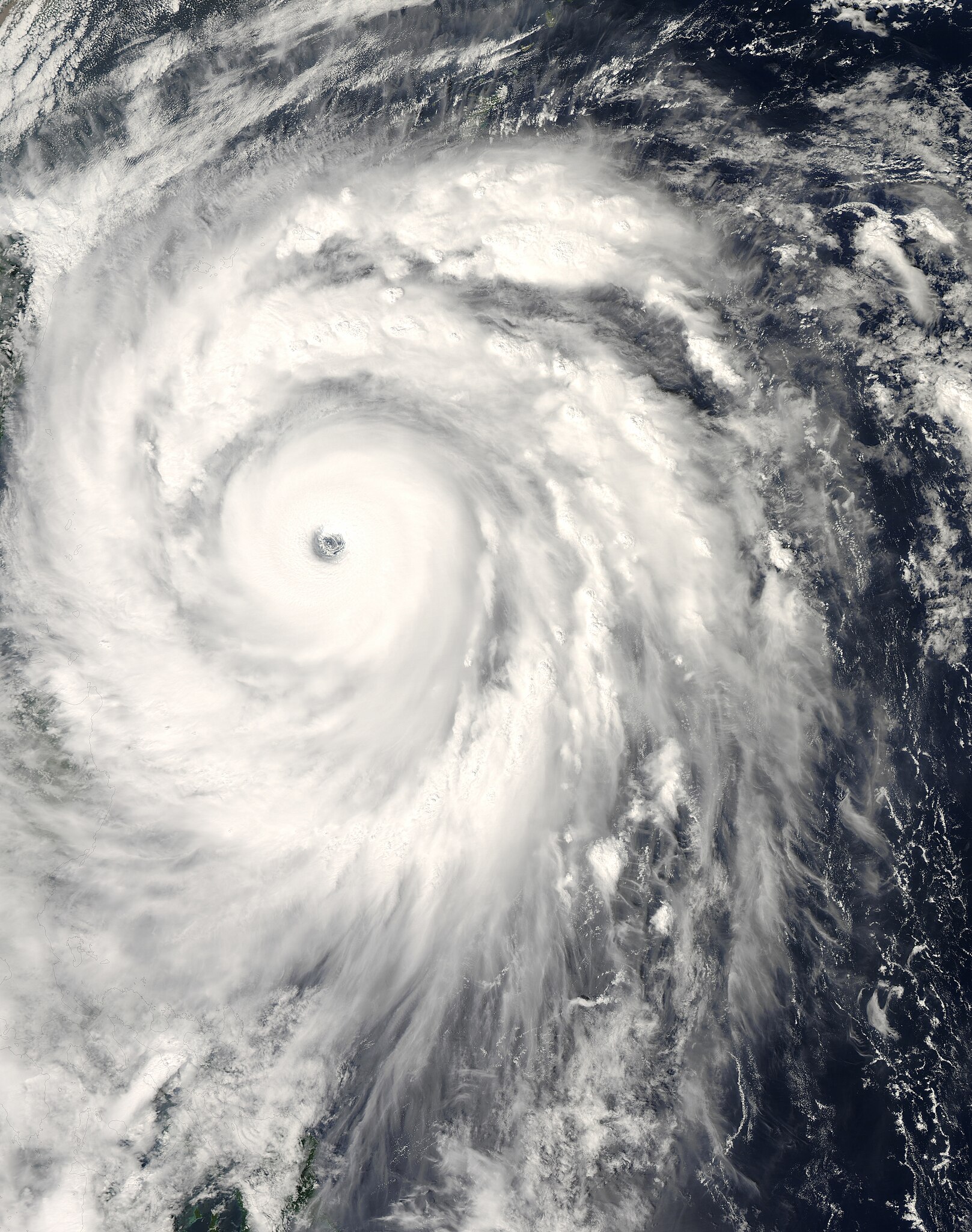
English: The title of “strongest storm of 2008” goes to Typhoon Jangmi, shown in this image from the Moderate Resolution Imaging Spectroradiometer (MODIS) on NASA’s Aqua satellite from September 27, 2008.
Seen from space, even a super typhoon seems more beautiful than dangerous. The 50-kilometer-wide eye of Jangmi is encircled by a smooth disk of clouds. Bands of clouds swirl gracefully into the low-pressure heart of the storm. The smooth cloud band north of the eye is studded with thunderstorms. On the ground, Jangmi was less lovely It was not only the strongest storm in any ocean basin in 2008 but the only storm to reach category 5 strength anywhere in the world that year. |
| 日付 | |
| 原典 | http://rapidfire.sci.gsfc.nasa.gov/cgi-bin/imagery/single.cgi?image=Jangmi.A2008271.0445.250m.jpg |
| 作者 | MODIS image captured by NASA’s Aqua satellite |
| カメラの位置 | | 以下のサービスでこの位置を確認する: オープンストリートマップ |
|---|
ライセンス
| このファイルはアメリカ航空宇宙局(NASA)によって作成されたものです。NASAの著作権の方針では、特記事項が無い場合、NASAの資料はパブリックドメインとなります。 (詳しくはTemplate:PD-USGov、NASAの著作権の方針について(英語)又はジェット推進研究所(JPL)の画像使用に関するガイドライン(英語)をご覧ください。) |
||
 |
注意事項:
|
ファイルの履歴
過去の版のファイルを表示するには、その版の日時をクリックしてください。
| 日付と時刻 | サムネイル | 寸法 | 利用者 | コメント | |
|---|---|---|---|---|---|
| 現在の版 | 2018年5月30日 (水) 13:58 | | 6,000 × 7,600 (4.93メガバイト) | Nino Marakot | Reverted to version as of 05:09, 9 January 2018 (UTC) |
| 2018年4月21日 (土) 23:03 |  | 1,723 × 2,089 (1.06メガバイト) | Saxitoxin | Less gray | |
| 2018年4月21日 (土) 23:02 |  | 1,723 × 2,089 (2.64メガバイト) | Saxitoxin | More storm centered | |
| 2018年1月9日 (火) 05:09 |  | 6,000 × 7,600 (4.93メガバイト) | Nino Marakot | Reverted to version as of 22:20, 2 November 2008 (UTC) - It's gallery version. Please separate them (it would become 3rd party if stayed) | |
| 2017年11月24日 (金) 15:48 |  | 5,985 × 7,980 (9.62メガバイト) | Meow | Rebuilt. | |
| 2008年11月2日 (日) 22:20 |  | 6,000 × 7,600 (4.93メガバイト) | Cyclonebiskit | {{Information |Description={{en|1={{en|1=Satellite image of Typhoon Jangmi at 0445 UTC Sept. 27, 2008.}}This photo-like image was taken by the Aqua MODIS Satellite as Typhoon Jangmi (or Super Typhoon 19W according to the JTWC) moved closer to the island o |
ファイルの使用状況
以下の 2 ページがこのファイルを使用しています:
グローバルなファイル使用状況
以下に挙げる他のウィキがこの画像を使っています:
- de.wikipedia.org での使用状況
- en.wikipedia.org での使用状況
- ko.wikipedia.org での使用状況
- pt.wikipedia.org での使用状況
- vi.wikipedia.org での使用状況
- zh-yue.wikipedia.org での使用状況
- zh.wikipedia.org での使用状況