
ファイル:Island of Ireland location map Leitrim.svg

この SVG ファイルのこの PNG プレビューのサイズ: 481 × 599 ピクセル. その他の解像度: 192 × 240 ピクセル | 385 × 480 ピクセル | 616 × 768 ピクセル | 822 × 1,024 ピクセル | 1,643 × 2,048 ピクセル | 1,450 × 1,807 ピクセル。
元のファイル (SVG ファイル、1,450 × 1,807 ピクセル、ファイルサイズ: 642キロバイト)
ウィキメディア・コモンズのファイルページにある説明を、以下に表示します。
|
| 解説 |
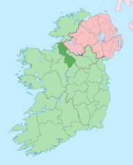
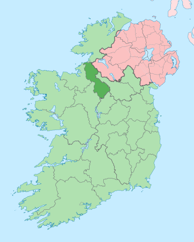
English: The island of Ireland, showing international border between Ireland and Northern Ireland, traditional provinces, traditional counties, and local authority areas in Ireland and Northern Ireland. |
| 日付 | (UTC) |
| 原典 | |
| 作者 |
|
この画像には画像編集が施されています。原本に対して次のデジタル的な変更が行われました。
|
この作品の著作権者である私は、この作品を以下のライセンスで提供します。
このファイルはクリエイティブ・コモンズ 表示-継承 3.0 非移植ライセンスのもとに利用を許諾されています。
- あなたは以下の条件に従う場合に限り、自由に
- 共有 – 本作品を複製、頒布、展示、実演できます。
- 再構成 – 二次的著作物を作成できます。
- あなたの従うべき条件は以下の通りです。
- 表示 – あなたは適切なクレジットを表示し、ライセンスへのリンクを提供し、変更があったらその旨を示さなければなりません。これらは合理的であればどのような方法で行っても構いませんが、許諾者があなたやあなたの利用行為を支持していると示唆するような方法は除きます。
- 継承 – もしあなたがこの作品をリミックスしたり、改変したり、加工した場合には、あなたはあなたの貢献部分を元の作品とこれと同一または互換性があるライセンスの下に頒布しなければなりません。
元のアップロードログ
This image is a derivative work of the following images:
- File:Island_of_Ireland_location_map.svg licensed with Cc-by-sa-3.0
- 2010-03-06T20:43:33Z Rannpháirtí anaithnid 1450x1807 (679207 Bytes) Fix incorrectly coloured isands.
- 2010-03-03T22:19:29Z Rannpháirtí anaithnid 1450x1807 (679744 Bytes) {{Information |Description={{de|Positionskarte von [[:de:Irland|Irland]]}} Quadratische Plattkarte, N-S-Streckung 170 %. Geographische Begrenzung der Karte: * N: 55.6° N * S: 51.2° N * W: 11.0° W * O: 5.0° W {{en|Location
Uploaded with derivativeFX
ファイルの履歴
過去の版のファイルを表示するには、その版の日時をクリックしてください。
| 日付と時刻 | サムネイル | 寸法 | 利用者 | コメント | |
|---|---|---|---|---|---|
| 現在の版 | 2020年6月28日 (日) 14:00 | | 1,450 × 1,807 (642キロバイト) | Chipmunkdavis | Per the Local Government Reform Act 2014, joining both Tipperarys and both Waterfords (and removing Limerick City code). Colouring in islands, cleaning up and grouping code to remove stray objects and show Galway and Lough Ree. |
| 2010年7月19日 (月) 00:51 |  | 1,450 × 1,807 (815キロバイト) | Mabuska | {{Information |Description={{en|The island of Ireland, showing international border between Northern Ireland and Republic of Ireland, traditional provinces, traditional counties, and local authority areas in the Republic of Ireland and Northern Ireland.}} |
ファイルの使用状況
以下のページがこのファイルを使用しています:
グローバルなファイル使用状況
以下に挙げる他のウィキがこの画像を使っています:
- ar.wikipedia.org での使用状況
- ast.wikipedia.org での使用状況
- bg.wikipedia.org での使用状況
- ca.wikipedia.org での使用状況
- ceb.wikipedia.org での使用状況
- cs.wikipedia.org での使用状況
- de.wikivoyage.org での使用状況
- en.wikipedia.org での使用状況
- County Leitrim
- List of Ireland-related topics
- Carrick-on-Shannon
- Ballinamore
- Carrigallen
- Manorhamilton
- Dromod
- Drumshanbo
- Mohill
- Roosky
- Buckode
- Dromahair
- Drumkeeran
- Keshcarrigan
- Kiltyclogher
- Kinlough
- Largydonnell
- Leitrim, County Leitrim
- Rossinver
- Tullaghan
- R203 road (Ireland)
- Dowra
- Dartry Mountains
- Lough MacNean
- Gorvagh
- Cornashamsogue
- Template:Leitrim-geo-stub
- Dristernan
- Lavagh (Leitrim barony)
- Cloonsheebane
- Effrinagh
- Newtowngore
- Ballinaglera
- Kiltubbrid
- Aghamore
- Eslinbridge
このファイルのグローバル使用状況を表示する。