
ファイル:Intercitynet NL 2012.png

このプレビューのサイズ: 507 × 599 ピクセル。 その他の解像度: 203 × 240 ピクセル | 406 × 480 ピクセル | 650 × 768 ピクセル | 866 × 1,024 ピクセル | 1,686 × 1,993 ピクセル。
元のファイル (1,686 × 1,993 ピクセル、ファイルサイズ: 128キロバイト、MIME タイプ: image/png)
ウィキメディア・コモンズのファイルページにある説明を、以下に表示します。
|
概要
| 解説 |
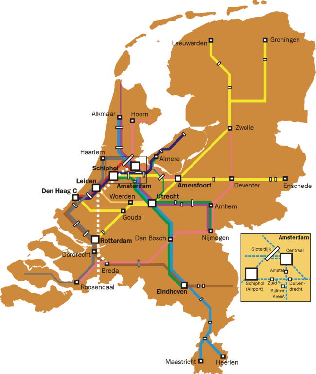
English: Map of the Dutch Intercity network. Thin lines are used for all-stops services that are a continuation of intercity services (e.g. the Rotterdam-Gouda-Amsterdam leg of the Enkhuizen-Rotterdam trains, and the Roosendaal - Vlissingen leg of the Amsterdam-Vlissingen trains).
Further notes:
|
| 日付 | |
| 原典 | 投稿者自身による著作物 |
| 作者 | Classical geographer |
ライセンス
この作品の著作権者である私は、この作品を以下のライセンスで提供します。
このファイルはクリエイティブ・コモンズ 表示-継承 3.0 非移植ライセンスのもとに利用を許諾されています。
- あなたは以下の条件に従う場合に限り、自由に
- 共有 – 本作品を複製、頒布、展示、実演できます。
- 再構成 – 二次的著作物を作成できます。
- あなたの従うべき条件は以下の通りです。
- 表示 – あなたは適切なクレジットを表示し、ライセンスへのリンクを提供し、変更があったらその旨を示さなければなりません。これらは合理的であればどのような方法で行っても構いませんが、許諾者があなたやあなたの利用行為を支持していると示唆するような方法は除きます。
- 継承 – もしあなたがこの作品をリミックスしたり、改変したり、加工した場合には、あなたはあなたの貢献部分を元の作品とこれと同一または互換性があるライセンスの下に頒布しなければなりません。

|
この文書は、フリーソフトウェア財団発行のGNUフリー文書利用許諾書 (GNU Free Documentation License) 1.2またはそれ以降のバージョンの規約に基づき、複製や再配布、改変が許可されます。不可変更部分、表紙、背表紙はありません。このライセンスの複製は、GNUフリー文書利用許諾書という章に含まれています。 |
あなたは上記のライセンスから、どれか一つ以上を選択できます。
ファイルの履歴
過去の版のファイルを表示するには、その版の日時をクリックしてください。
| 日付と時刻 | サムネイル | 寸法 | 利用者 | コメント | |
|---|---|---|---|---|---|
| 現在の版 | 2012年1月11日 (水) 19:44 | | 1,686 × 1,993 (128キロバイト) | Classical geographer | Now uploaded correct version, indeed without Best. |
| 2011年11月14日 (月) 19:03 |  | 1,686 × 1,993 (128キロバイト) | Classical geographer | Added Delft and Schiedam, removed Best. | |
| 2011年8月5日 (金) 17:37 |  | 1,686 × 1,993 (523キロバイト) | Classical geographer | Updated to 2012. | |
| 2011年8月5日 (金) 17:36 |  | 4,216 × 4,984 (439キロバイト) | Classical geographer | Updated to 2012. | |
| 2009年10月16日 (金) 14:57 |  | 2,810 × 3,323 (610キロバイト) | T n g old commons | De intercity naar venlo rijdt pas na Deurne als stoptrein. Na eindhoven skipt hij nog de stations Helmond Brandevoort en Helmond 't Hout, waarnaar de intercity stopt op station helmond, en daarna weer station Brouwhuis skipt, dan stopt hij op deurne, wat | |
| 2009年3月12日 (木) 16:45 |  | 2,810 × 3,323 (511キロバイト) | Classical geographer | {{Information |Description={{en|1=Map of the Dutch Intercity network. Narrower lines are intercities that run an all-stops service. (On the Rotterdam-Gouda-Amsterdam line, the intercity is even officially called Stoptrein, but it is still indicated here.) |
ファイルの使用状況
以下のページがこのファイルを使用しています:
グローバルなファイル使用状況
以下に挙げる他のウィキがこの画像を使っています:
- nl.wikipedia.org での使用状況