
ファイル:Hundred years war.gif

このプレビューのサイズ: 522 × 599 ピクセル。 その他の解像度: 209 × 240 ピクセル | 541 × 621 ピクセル。
元のファイル (541 × 621 ピクセル、ファイルサイズ: 140キロバイト、MIME タイプ: image/gif、ループします、10 フレーム、35秒)
ウィキメディア・コモンズのファイルページにある説明を、以下に表示します。
|
概要
| 解説 |
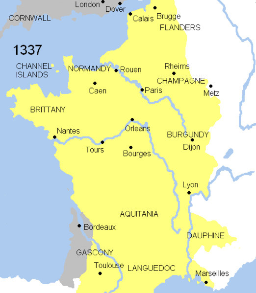
English: Animated map Hundred years war. This map shows the war`s evolution and the most important battles.
Displayed in the map: France
England
Burgundy
Battles-Battle of Crecy (1346), Battle of Poitiers (1356), Battle of Agincourt (1415), Battle of Castillon (1429), Battle of Formigny (1450)
Years shown: 1337, 1346, 1356, 1360, 1415, 1429, 1429-31, 1450, 1451-53, 1453. |
| 日付 | |
| 原典 | |
| 作者 | Andrein (d) |
ライセンス
| この著作物は、著作者であるAndreinによって権利が放棄され、パブリックドメインとされました。これは全世界で適用されます。 一部の国では、これが法的に可能ではない場合があります。その場合は、次のように宣言します。 |

|
This map has been uploaded by Electionworld from en.wikipedia.org to enable the |
ファイルの履歴
過去の版のファイルを表示するには、その版の日時をクリックしてください。
| 日付と時刻 | サムネイル | 寸法 | 利用者 | コメント | |
|---|---|---|---|---|---|
| 現在の版 | 2008年7月21日 (月) 08:37 | | 541 × 621 (140キロバイト) | Chphe | without watermark |
| 2007年3月17日 (土) 12:23 |  | 541 × 621 (139キロバイト) | Electionworld | == Licensing == {{PD-self}} {{ew|en|Andrei Nacu}} Category:Maps of the history of France == File History in Wikipedia== Legend: (cur) = this is the current file, (del) = delete this old version, (rev) = revert to this old version. Click on date to do |
ファイルの使用状況
以下の 3 ページがこのファイルを使用しています:
グローバルなファイル使用状況
以下に挙げる他のウィキがこの画像を使っています:
- am.wikipedia.org での使用状況
- azb.wikipedia.org での使用状況
- az.wikipedia.org での使用状況
- ba.wikipedia.org での使用状況
- be.wikipedia.org での使用状況
- bg.wikipedia.org での使用状況
- ca.wikipedia.org での使用状況
- crh.wikipedia.org での使用状況
- cs.wikipedia.org での使用状況
- cy.wikipedia.org での使用状況
- diq.wikipedia.org での使用状況
- en.wikipedia.org での使用状況
- en.wikibooks.org での使用状況
- eo.wikipedia.org での使用状況
- es.wikipedia.org での使用状況
- et.wikipedia.org での使用状況
- fa.wikipedia.org での使用状況
- fr.wikipedia.org での使用状況
- ga.wikipedia.org での使用状況
- he.wikipedia.org での使用状況
- hif.wikipedia.org での使用状況
- hu.wikipedia.org での使用状況
- id.wikibooks.org での使用状況
- is.wikipedia.org での使用状況
- it.wikipedia.org での使用状況
- ka.wikipedia.org での使用状況
- ko.wikipedia.org での使用状況
- krc.wikipedia.org での使用状況
- la.wikipedia.org での使用状況
このファイルのグローバル使用状況を表示する。