
ファイル:French Hercynian massifs EN.svg

この SVG ファイルのこの PNG プレビューのサイズ: 800 × 555 ピクセル. その他の解像度: 320 × 222 ピクセル | 640 × 444 ピクセル | 1,024 × 711 ピクセル | 1,280 × 888 ピクセル | 2,560 × 1,777 ピクセル | 850 × 590 ピクセル。
元のファイル (SVG ファイル、850 × 590 ピクセル、ファイルサイズ: 274キロバイト)
ウィキメディア・コモンズのファイルページにある説明を、以下に表示します。
|
概要
| 解説 |
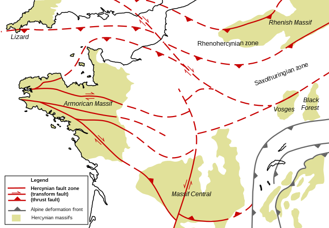
English: Structural geologic map of the north of France, showing Hercynian massifs and structures. Based on figures and information in the following literature:
|
| 日付 | |
| 原典 | 投稿者自身による著作物 |
| 作者 | Woudloper |
| その他のバージョン |
 |
ライセンス
| この著作物の著作権者である私は、この著作物における権利を放棄しパブリックドメインとします。これは全世界で適用されます。 一部の国では、これが法的に可能ではない場合があります。その場合は、次のように宣言します。 私は、あらゆる人に対して、法により必要とされている条件を除き、如何なる条件も課すことなく、あらゆる目的のためにこの著作物を使用する権利を与えます。 |
ファイルの履歴
過去の版のファイルを表示するには、その版の日時をクリックしてください。
| 日付と時刻 | サムネイル | 寸法 | 利用者 | コメント | |
|---|---|---|---|---|---|
| 現在の版 | 2008年11月27日 (木) 21:37 | | 850 × 590 (274キロバイト) | Woudloper | {{Information |Description={{en|1=Structural geologic map of the north of France, showing Hercynian massifs and structures. Based on figures and information in the following literature: *{{aut|Service Géologique National}}; '''1996''': ''Carte géologiqu |
ファイルの使用状況
以下のページがこのファイルを使用しています:
グローバルなファイル使用状況
以下に挙げる他のウィキがこの画像を使っています:
- en.wikipedia.org での使用状況
- ro.wikipedia.org での使用状況
- uk.wikipedia.org での使用状況
- zh.wikipedia.org での使用状況