
ファイル:Europe 1740 en.png

このプレビューのサイズ: 800 × 570 ピクセル。 その他の解像度: 320 × 228 ピクセル | 640 × 456 ピクセル | 1,024 × 730 ピクセル | 1,280 × 913 ピクセル | 2,560 × 1,825 ピクセル | 3,872 × 2,761 ピクセル。
元のファイル (3,872 × 2,761 ピクセル、ファイルサイズ: 1.25メガバイト、MIME タイプ: image/png)
ウィキメディア・コモンズのファイルページにある説明を、以下に表示します。
|
_en.png)
.png)
.jpg)
概要
| 解説 |
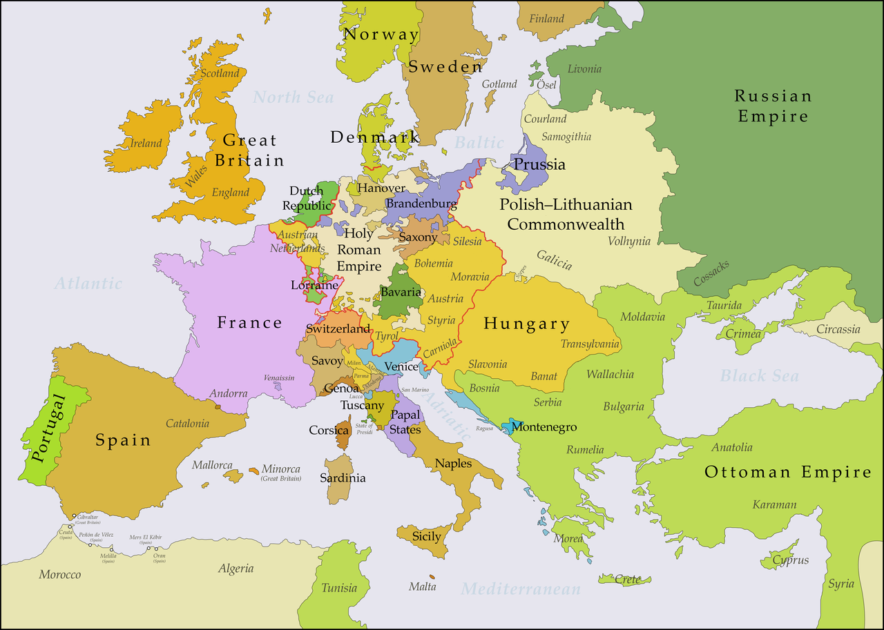
English: This map shows Europe in the years between the 1739 Treaty of Belgrade (the end of the Austro–Turkish War (1737–39)) and the beginning of the War of the Austrian Succession in 1740. The red line marks the borders of the Holy Roman Empire. The work was created with Inkscape and is mainly based on a map in: Putzger - Historischer Weltatlas, Berlin 1990, 78 pp. |
| 日付 | |
| 原典 | 投稿者自身による著作物, based on File:Europe 1748-1766 en.png |
| 作者 | Bryan Rutherford |
ライセンス
この作品の著作権者である私は、この作品を以下のライセンスで提供します。
このファイルはクリエイティブ・コモンズ 表示-継承 4.0 国際ライセンスのもとに利用を許諾されています。
- あなたは以下の条件に従う場合に限り、自由に
- 共有 – 本作品を複製、頒布、展示、実演できます。
- 再構成 – 二次的著作物を作成できます。
- あなたの従うべき条件は以下の通りです。
- 表示 – あなたは適切なクレジットを表示し、ライセンスへのリンクを提供し、変更があったらその旨を示さなければなりません。これらは合理的であればどのような方法で行っても構いませんが、許諾者があなたやあなたの利用行為を支持していると示唆するような方法は除きます。
- 継承 – もしあなたがこの作品をリミックスしたり、改変したり、加工した場合には、あなたはあなたの貢献部分を元の作品とこれと同一または互換性があるライセンスの下に頒布しなければなりません。
ファイルの履歴
過去の版のファイルを表示するには、その版の日時をクリックしてください。
| 日付と時刻 | サムネイル | 寸法 | 利用者 | コメント | |
|---|---|---|---|---|---|
| 現在の版 | 2018年7月15日 (日) 21:49 | | 3,872 × 2,761 (1.25メガバイト) | Bryanrutherford0 | Added the Ionian Islands, made the Duchy of Milan a Habsburg possession |
| 2018年7月10日 (火) 02:28 |  | 3,872 × 2,761 (1.25メガバイト) | Bryanrutherford0 | Added Comtat Venaissin and redrew borders of Neuchâtel, Bishopric Basel, and Montbéliard | |
| 2017年10月3日 (火) 00:39 |  | 3,872 × 2,761 (1.25メガバイト) | Bryanrutherford0 | Transferred control of Saaremaa and Hiiumaa to Russia (1721 Treaty of Nystad) | |
| 2017年8月24日 (木) 12:50 |  | 3,872 × 2,761 (1.25メガバイト) | Bryanrutherford0 | Removed Prussian East Frisia (acquired 1744) | |
| 2017年8月23日 (水) 20:17 |  | 3,872 × 2,761 (1.25メガバイト) | Bryanrutherford0 | User created page with UploadWizard |
ファイルの使用状況
以下の 2 ページがこのファイルを使用しています:
グローバルなファイル使用状況
以下に挙げる他のウィキがこの画像を使っています:
- azb.wikipedia.org での使用状況
- bg.wikipedia.org での使用状況
- ca.wikipedia.org での使用状況
- cs.wikipedia.org での使用状況
- de.wikipedia.org での使用状況
- el.wikipedia.org での使用状況
- en.wikipedia.org での使用状況
- es.wikipedia.org での使用状況
- fa.wikipedia.org での使用状況
- fi.wikipedia.org での使用状況
- fr.wikipedia.org での使用状況
- gcr.wikipedia.org での使用状況
- he.wikipedia.org での使用状況
- id.wikipedia.org での使用状況
- it.wikipedia.org での使用状況
- lv.wikipedia.org での使用状況
- pt.wikipedia.org での使用状況
- ru.wikipedia.org での使用状況
- sr.wikipedia.org での使用状況
- zh.wikipedia.org での使用状況