
ファイル:ElectoralCollege1984-Large.png
このプレビューのサイズ: 800 × 430 ピクセル。 その他の解像度: 320 × 172 ピクセル | 640 × 344 ピクセル | 1,182 × 635 ピクセル。
元のファイル (1,182 × 635 ピクセル、ファイルサイズ: 163キロバイト、MIME タイプ: image/png)
ウィキメディア・コモンズのファイルページにある説明を、以下に表示します。
|
| U.S. presidential election maps from the National Atlas of the United States |
| See also: SVG maps |
| 1789 · 1792 · 1796 · 1800 · 1804 · 1808 · 1812 · 1816 · 1820 · 1824 · 1828 · 1832 · 1836 · 1840 · 1844 · 1848 · 1852 · 1856 · 1860 · 1864 · 1868 · 1872 · 1876 · 1880 · 1884 · 1888 · 1892 · 1896 · 1900 · 1904 · 1908 · 1912 · 1916 · 1920 · 1924 · 1928 · 1932 · 1936 · 1940 · 1944 · 1948 · 1952 · 1956 · 1960 · 1964 · 1968 · 1972 · 1976 · 1980 · 1984 · 1988 · 1992 · 1996 · 2000 · 2004 |
概要
| 解説 |
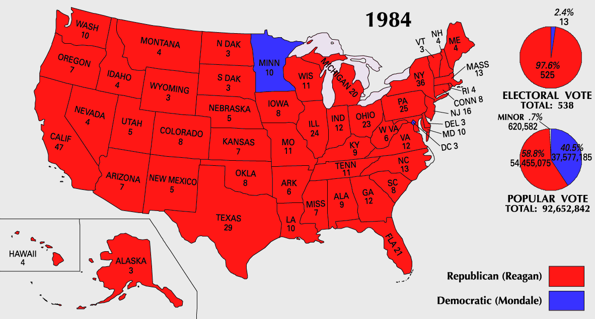
English: 1984 Electoral College Map |
|||
| 原典 | https://nationalmap.gov/small_scale/printable/elections.html | |||
| 作者 | アメリカ地質調査所 | |||
| その他のバージョン |
|


ライセンス
This map was obtained from an edition of the National Atlas of the United States. Like almost all works of the U.S. federal government, works from the National Atlas are in the public domain in the United States.
Online access: NationalAtlas.gov | 1970 print edition: Library of Congress, Perry-Castañeda Library
|
ファイルの履歴
過去の版のファイルを表示するには、その版の日時をクリックしてください。
| 日付と時刻 | サムネイル | 寸法 | 利用者 | コメント | |
|---|---|---|---|---|---|
| 現在の版 | 2007年7月25日 (水) 10:20 | | 1,182 × 635 (163キロバイト) | Cardsplayer4life~commonswiki | Reverted to earlier revision |
| 2007年7月25日 (水) 09:32 |  | 1,182 × 635 (104キロバイト) | Joseph Solis in Australia~commonswiki | {{PD-USGov-Atlas}} Category:1988 {{US presidential election maps}} | |
| 2007年7月9日 (月) 01:46 |  | 1,182 × 635 (163キロバイト) | Cardsplayer4life~commonswiki | {{PD-USGov-Atlas}} Category:1984 {{US presidential election maps}} | |
| 2007年7月6日 (金) 09:36 |  | 1,182 × 635 (104キロバイト) | Joseph Solis in Australia~commonswiki | {{PD-USGov-Atlas}} Category:1984 {{US presidential election maps}} | |
| 2007年7月2日 (月) 02:28 |  | 1,182 × 635 (163キロバイト) | Cardsplayer4life~commonswiki | {{PD-USGov-Atlas}} Category:1984 {{US presidential election maps}} | |
| 2007年6月29日 (金) 10:14 |  | 1,182 × 635 (104キロバイト) | Joseph Solis in Australia~commonswiki | {{PD-USGov-Atlas}} Category:1984 {{US presidential election maps}} | |
| 2007年6月21日 (木) 21:07 |  | 1,182 × 635 (163キロバイト) | Cardsplayer4life~commonswiki | {{PD-USGov-Atlas}} Category:1984 {{US presidential election maps}} | |
| 2007年5月31日 (木) 08:27 |  | 1,182 × 635 (104キロバイト) | Joseph Solis in Australia~commonswiki | {{PD-USGov-Atlas}} Category:1984 {{US presidential election maps}} | |
| 2006年5月25日 (木) 20:06 |  | 1,182 × 635 (89キロバイト) | JP06035 | switched colors | |
| 2006年1月22日 (日) 16:08 |  | 1,182 × 635 (104キロバイト) | Red devil 666 | {{PD-USGov-Atlas}} |
ファイルの使用状況
このファイルを使用しているページはありません。
グローバルなファイル使用状況
以下に挙げる他のウィキがこの画像を使っています:
- hu.wikipedia.org での使用状況