
ファイル:East and West Florida 1810.jpg
高解像度版はありません。
East_and_West_Florida_1810.jpg (412 × 245 ピクセル、ファイルサイズ: 44キロバイト、MIME タイプ: image/jpeg)
ウィキメディア・コモンズのファイルページにある説明を、以下に表示します。
|
| 解説 |
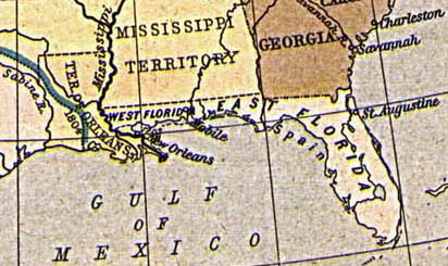
English: Map of East and West Florida in 1810, from the Perry-Castañeda Map Collection [1]. The boundary between the two provinces is incorrect; it was at the Apalachicola River, not the Perdido River (as shown here).
Español: Mapa de Florida Oriental y Florida Occidental en 1810, de la Collección Perry-Castañeda de Mapas[2]. La frontera entre las dos provincias no es correcto; la frontera era el Rio Apalachicola, no el Perdido (como se aparece aquí).
Deutsch: Karte von Ost- und Westflorida 1810. Aus der Kartensammlung der Perry-Castañeda Bibliothek[3]. Die Grenze zwischen Ost- und Westflorida ist unrichtig; die richtige Grenze war der Apalachicola-Fluss anstatt dem Perdido.
Français : Carte de Floride occidentale et de Floride orientale en 1810, provenant de la collection cartographique Perry-Castañeda [4].
La frontière indiquée entre les deux provinces est erronée : elle était formée par le fleuve Apalachicola, et non le fleuve Perdido représenté ici. |
| 日付 | 1923. Provided on 11 August 2005 by en:User:JW1805 to the English Wikipedia. |
| 原典 | From "The Historical Atlas" by William R. Shepherd, 1923. http://www.lib.utexas.edu/maps/historical/shepherd/us_expansion_shepherd.jpg |
| 作者 |
![[1]](http://www.lib.utexas.edu/maps/historical/shepherd/us_expansion_shepherd.jpg)
|
この著作物は、著作権の保護期間が著作者の死後70年以下である国・地域においてパブリックドメインの状態にあります。
| |
| このファイルは著作権法の既知の制約(隣接権や関連する権利を含む)から自由であると特定されています。 | |
ファイルの履歴
過去の版のファイルを表示するには、その版の日時をクリックしてください。
| 日付と時刻 | サムネイル | 寸法 | 利用者 | コメント | |
|---|---|---|---|---|---|
| 現在の版 | 2005年8月20日 (土) 13:30 | | 412 × 245 (44キロバイト) | Sebastian Wallroth | '''en: ''' Map of East and West Florida in 1810. From the Perry-Castañeda Library Map Collection [http://www.lib.utexas.edu/maps/historical/shepherd/us_expansion_shepherd.jpg]. '''de:''' Karte von Ost- und Westflorida 1810. Aus der Kartensammlung der |
ファイルの使用状況
以下の 5 ページがこのファイルを使用しています:
グローバルなファイル使用状況
以下に挙げる他のウィキがこの画像を使っています:
- br.wikipedia.org での使用状況
- ca.wikipedia.org での使用状況
- da.wikipedia.org での使用状況
- de.wikipedia.org での使用状況
- es.wikipedia.org での使用状況
- fr.wikipedia.org での使用状況
- gl.wikipedia.org での使用状況
- hi.wikipedia.org での使用状況
- hu.wikipedia.org での使用状況
- id.wikipedia.org での使用状況
- it.wikipedia.org での使用状況
- ko.wikipedia.org での使用状況
- mk.wikipedia.org での使用状況
- nn.wikipedia.org での使用状況
- no.wikipedia.org での使用状況
- pam.wikipedia.org での使用状況
- pt.wikipedia.org での使用状況
- ro.wikipedia.org での使用状況
- ru.wikipedia.org での使用状況
- sco.wikipedia.org での使用状況
- sv.wikipedia.org での使用状況