
ファイル:Discovery Expedition field of work.png

このプレビューのサイズ: 800 × 538 ピクセル。 その他の解像度: 320 × 215 ピクセル | 640 × 430 ピクセル | 890 × 598 ピクセル。
元のファイル (890 × 598 ピクセル、ファイルサイズ: 60キロバイト、MIME タイプ: image/png)
ウィキメディア・コモンズのファイルページにある説明を、以下に表示します。
|
概要
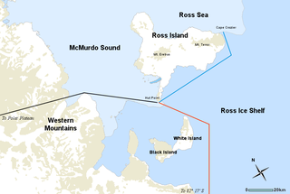
| 解説 | Map of the Discovery Expedition field of work, including three routes of explorations undertaken by members of the British National Antarctic Expedition of 1901-04 led by Robert Falcon Scott. RED line; Southern journey to Furthest South, November 1902 to February 1903. BLACK line; Western journey through Western Mountains to Polar Plateau, October–December 1903. BLUE line; Journeys to message point and Emperor Penguin colony at Cape Crozier, October 1902, September and October 1903. |
| 日付 | |
| 原典 | Underlying map from the Atlas of Antarctic Research by the United States Geological Survey (a public domain work). Includes Image:Simple compass rose.svg. |
| 作者 | Map by USGS, additional modifications by Holly Cheng |
| その他のバージョン |
このファイルの派生的著作物: |
ライセンス
| この著作物の著作権者である私は、この著作物における権利を放棄しパブリックドメインとします。これは全世界で適用されます。 一部の国では、これが法的に可能ではない場合があります。その場合は、次のように宣言します。 私は、あらゆる人に対して、法により必要とされている条件を除き、如何なる条件も課すことなく、あらゆる目的のためにこの著作物を使用する権利を与えます。 |
ファイルの履歴
過去の版のファイルを表示するには、その版の日時をクリックしてください。
| 日付と時刻 | サムネイル | 寸法 | 利用者 | コメント | |
|---|---|---|---|---|---|
| 現在の版 | 2008年5月3日 (土) 00:21 | | 890 × 598 (60キロバイト) | Holly Cheng | corrected inaccuracy |
| 2008年5月2日 (金) 19:53 |  | 890 × 598 (66キロバイト) | Holly Cheng | removed top border | |
| 2008年5月2日 (金) 19:43 |  | 890 × 600 (63キロバイト) | Holly Cheng | {{Information |Description=Map of the ''{{w:Discovery Expedition}}'' field of work, including three routes of explorations undertaken by members of the British National Antarctic Expedition of 1901-04 led by Robert Falcon Scott |Source=Underlying map from |
ファイルの使用状況
以下のページがこのファイルを使用しています:
グローバルなファイル使用状況
以下に挙げる他のウィキがこの画像を使っています:
- be.wikipedia.org での使用状況
- da.wikipedia.org での使用状況
- en.wikipedia.org での使用状況
- fi.wikipedia.org での使用状況
- fr.wikipedia.org での使用状況
- he.wikipedia.org での使用状況
- ka.wikipedia.org での使用状況
- mk.wikipedia.org での使用状況
- nl.wikipedia.org での使用状況
- nn.wikipedia.org での使用状況
- no.wikipedia.org での使用状況
- pl.wikipedia.org での使用状況
- pt.wikipedia.org での使用状況
- ro.wikipedia.org での使用状況
- vi.wikipedia.org での使用状況
- zh.wikipedia.org での使用状況