
ファイル:Chariot spread.png
高解像度版はありません。
Chariot_spread.png (400 × 231 ピクセル、ファイルサイズ: 154キロバイト、MIME タイプ: image/png)
ウィキメディア・コモンズのファイルページにある説明を、以下に表示します。
|
| 解説 |
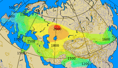
Historical spread of the chariot. This map combines various classes of information, historical and archaeological. The 'isochrones' as given should not be considered more than rough approximations, give or take a century.
|
||||||||
| 日付 | |||||||||
| 原典 | 投稿者自身による著作物 by by en:User:Dbachmann | ||||||||
| 作者 | by en:User:Dbachmann | ||||||||
| 許可 (ファイルの再利用) |
|
||||||||
| その他のバージョン |
|


ファイルの履歴
過去の版のファイルを表示するには、その版の日時をクリックしてください。
| 日付と時刻 | サムネイル | 寸法 | 利用者 | コメント | |
|---|---|---|---|---|---|
| 現在の版 | 2021年9月27日 (月) 04:00 | | 400 × 231 (154キロバイト) | GPinkerton | Reverted to version as of 14:14, 17 August 2005 (UTC) COM:CROP |
| 2021年5月2日 (日) 19:28 |  | 400 × 231 (161キロバイト) | Claude Zygiel | North Africa too (Raymond Vaufrey, Préhistoire de l'Afrique, tome II, Service des Publications de l'Université de Tunis, 1969) | |
| 2005年8月17日 (水) 14:14 |  | 400 × 231 (154キロバイト) | Dbachmann | correction, labels | |
| 2005年8月17日 (水) 07:14 |  | 350 × 202 (119キロバイト) | Dbachmann | by en:User:Dbachmann {{GFDL}} |
ファイルの使用状況
以下の 3 ページがこのファイルを使用しています:
グローバルなファイル使用状況
以下に挙げる他のウィキがこの画像を使っています:
- az.wikipedia.org での使用状況
- ba.wikipedia.org での使用状況
- bn.wikipedia.org での使用状況
- ca.wikipedia.org での使用状況
- cs.wikipedia.org での使用状況
- da.wikipedia.org での使用状況
- de.wikipedia.org での使用状況
- en.wikipedia.org での使用状況
- es.wikipedia.org での使用状況
- eu.wikipedia.org での使用状況
- fa.wikipedia.org での使用状況
- fi.wikipedia.org での使用状況
- fi.wikibooks.org での使用状況
- fr.wikipedia.org での使用状況
- hak.wikipedia.org での使用状況
- he.wikipedia.org での使用状況
- hu.wikipedia.org での使用状況
- hy.wikipedia.org での使用状況
このファイルのグローバル使用状況を表示する。