
ファイル:Cassini-OntarioLacus-RADAR.jpg

元のファイル (1,411 × 1,276 ピクセル、ファイルサイズ: 329キロバイト、MIME タイプ: image/jpeg)
ウィキメディア・コモンズのファイルページにある説明を、以下に表示します。
|
概要
| 解説 |
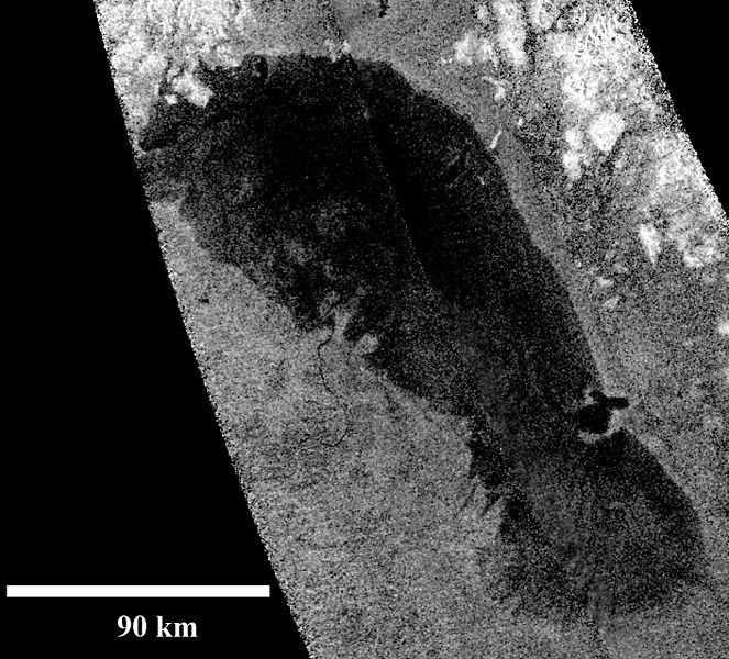
English: This RADAR-image of Ontario Lacus, the largest lake on the southern hemisphere of Saturn's moon Titan, was obtained by NASA's Cassini spacecraft on Jan. 12, 2010. North is up in this image.
Objects appear bright in this radar image when they are tilted toward the spacecraft or have rough surfaces. The lake surface appears dark because it is smooth. The northern shoreline features flooded river valleys and hills as high as 1 kilometer (3,000 feet) in altitude. A smooth, wave-sculpted shoreline, like that seen on the southeastern side of Lake Michigan, can be seen at the northeastern part of the lake. Smooth lines parallel to the current shoreline could be formed by low waves over time, which were likely driven by winds sweeping in from the west or southwest. The southeast shore features a round-headed bay intruding into the shore. The liquid-filled depressions appear to be relatively recent. The middle part of the western shoreline shows the first well-developed delta observed on Titan. The shape of the delta shows that liquid flowing down from a higher plain has switched channels on its way into the lake, forming at least two lobes. Examples of this kind of channel switching and wave-modified deltas can be found on Earth at the southern end of Lake Albert between Uganda and the Democratic Republic of Congo in Africa and the remains of an ancient lake known as Megachad in the African country Chad.Deutsch: Radarabtastung des Ontario Lacus, des größten Ethan-Methan-Sees auf der Südhalbkugel des größten Saturnmondes Titan aufgenommen durch die Raumsonde Cassini am 12. Januar, 2010.
Das nördliche Ufer ist geprägt durch ca. 1 km hohe Hügel sowie überflutete Flusstäler. Eine gerade verlaufende, wellengeformte Küstenlinie, ähnlich der des südwestlichen Michigansees, kann im nordöstlichen Bereich beobachtet werden. Parallel zum gegenwärtigen Ufer verlaufende Linien könnten über längere Zeiträume durch niedrige Wellen geformt worden sein, welche wiederum vermutlich aufgrund von West- oder Südwestwinden entstehen. Die südöstliche Küste zeigt eine rundliche, weit in den See ragende Bucht. Der mittlere Teil der westlichen Küste weist das erste beobachtete und gut ausgeprägte Flussdelta auf Titan auf. Ähnlich dem Rhône-Delta in der französischen Camargue, handelt es sich seiner Morphologie nach zu urteilen um ein wellendominiertes Delta, bei dem von höherliegenden Gebieten kommende flüssige Kohlenwasserstoffe auf ihrem Weg zum See ihre Flussrinne wechseln und so mindestens zwei Halbinseln geschaffen haben. Weitere Beispiele solcher Rinnenwechsel bzw. wellendominierter Deltas können auf der Erde am südlichen Ende des Albertsees in Afrika zwischen Uganda und der Demokratischen Republik Kongo sowie als Überreste des einstigen Binnenmeeres Mega-Tschad im Tschad gefunden werden. |
| 日付 | |
| 原典 | http://photojournal.jpl.nasa.gov/catalog/PIA13172 |
| 作者 | NASA/JPL-Caltech |
ライセンス
| このファイルはアメリカ航空宇宙局(NASA)によって作成されたものです。NASAの著作権の方針では、特記事項が無い場合、NASAの資料はパブリックドメインとなります。 (詳しくはTemplate:PD-USGov、NASAの著作権の方針について(英語)又はジェット推進研究所(JPL)の画像使用に関するガイドライン(英語)をご覧ください。) |
||
 |
注意事項:
|
ファイルの履歴
過去の版のファイルを表示するには、その版の日時をクリックしてください。
| 日付と時刻 | サムネイル | 寸法 | 利用者 | コメント | |
|---|---|---|---|---|---|
| 現在の版 | 2010年7月22日 (木) 18:08 | | 1,411 × 1,276 (329キロバイト) | 36ophiuchi~commonswiki | {{Information |Description={{en|1= This RADAR-image of Ontario Lacus, the largest lake on the southern hemisphere of Saturn's moon Titan, was obtained by NASA's Cassini spacecraft on Jan. 12, 2010. North is up in this image. Objects appear bright |
ファイルの使用状況
以下のページがこのファイルを使用しています:
グローバルなファイル使用状況
以下に挙げる他のウィキがこの画像を使っています:
- ar.wikipedia.org での使用状況
- ca.wikipedia.org での使用状況
- cs.wikipedia.org での使用状況
- de.wikipedia.org での使用状況
- en.wikipedia.org での使用状況
- en.wiktionary.org での使用状況
- fr.wikipedia.org での使用状況
- hr.wikipedia.org での使用状況
- id.wikipedia.org での使用状況
- it.wikipedia.org での使用状況
- it.wikibooks.org での使用状況
- it.wikiversity.org での使用状況
- ko.wikipedia.org での使用状況
- lb.wikipedia.org での使用状況
- nn.wikipedia.org での使用状況
- no.wikipedia.org での使用状況
- pl.wikipedia.org での使用状況
- pt.wikipedia.org での使用状況
- ru.wikipedia.org での使用状況
- www.wikidata.org での使用状況