ファイル:Cartogram-2008 Electoral Vote.png

ページのコンテンツが他言語でサポートされていません。

元のファイル(1,000 × 850 ピクセル、ファイルサイズ: 56キロバイト、MIME タイプ: image/png)

このファイルのベクター画像 (SVG) が利用できます。 使う目的に対し、元画像よりもSVGがより優れている場合、SVG画像を使用して下さい。

File:Cartogram-2008 Electoral Vote.png → File:Cartogram-2008 Electoral Vote.svg

ベクターグラフィックスの詳細については、コモンズのSVG変換を参照ください。
SVGのMediaWikiのサポートに関する情報もあります。

他言語
Alemannisch  Bahasa Indonesia  Bahasa Melayu  British English  català  čeština  dansk  Deutsch  eesti  English  español  Esperanto  euskara  français  Frysk  galego  hrvatski  Ido  italiano  lietuvių  magyar  Nederlands  norsk bokmål  norsk nynorsk  occitan  Plattdüütsch  polski  português  português do Brasil  română  Scots  sicilianu  slovenčina  slovenščina  suomi  svenska  Tiếng Việt  Türkçe  vèneto  Ελληνικά  беларуская (тарашкевіца)  български  македонски  нохчийн  русский  српски / srpski  татарча/tatarça  українська  ქართული  հայերեն  বাংলা  தமிழ்  മലയാളം  ไทย  한국어  日本語  简体中文  繁體中文  עברית  العربية  فارسی  +/−
新しいSVG画像

概要

解説
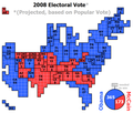
English: Cartogram of the 2008 Electoral Vote for US President, with each square representing one electoral vote. Nebraska, being one of two states that are not winner-take-all, for the first time had its votes split, with NE-2 voting for Obama and the rest of the state for McCain.

The population density of the 50 states varies by three orders of magnitude (from NJ with nearly 1,200 people per square mile, to AK with roughly 1 1/4 people per sq mi). Because of that huge variation, a regular map of the US that is typically used to present electoral vote results can convey a very skewed impression of the outcome where sparsely populated states appear overrepresented and densely populated states appear underrepresented. The cartogram approach of this image eliminates that problem by presenting the area of each state in an exact one-to-one correspondence with its number of electoral votes. But this is achieved at the cost of introducing distortions to the actual shape of each state and their positioning in relation to each other.
日付
原典 Own work by uploader (created with Powerpoint)
作者 ChrisnHouston
その他のバージョン

このファイルの派生的著作物:  Cartogram-2008 Electoral Vote-es.svg

Cartogram-2008 Electoral Vote.gif

ライセンス

この作品の著作権者である私は、この作品を以下のライセンスで提供します。
w:ja:クリエイティブ・コモンズ
表示 継承
このファイルはクリエイティブ・コモンズ 表示-継承 3.0 非移植ライセンスのもとに利用を許諾されています。
あなたは以下の条件に従う場合に限り、自由に
  • 共有 – 本作品を複製、頒布、展示、実演できます。
  • 再構成 – 二次的著作物を作成できます。
あなたの従うべき条件は以下の通りです。
  • 表示 – あなたは適切なクレジットを表示し、ライセンスへのリンクを提供し、変更があったらその旨を示さなければなりません。これらは合理的であればどのような方法で行っても構いませんが、許諾者があなたやあなたの利用行為を支持していると示唆するような方法は除きます。
  • 継承 – もしあなたがこの作品をリミックスしたり、改変したり、加工した場合には、あなたはあなたの貢献部分を元の作品とこれと同一または互換性があるライセンスの下に頒布しなければなりません。
GNU head この文書は、フリーソフトウェア財団発行のGNUフリー文書利用許諾書 (GNU Free Documentation License) 1.2またはそれ以降のバージョンの規約に基づき、複製や再配布、改変が許可されます。不可変更部分、表紙、背表紙はありません。このライセンスの複製は、GNUフリー文書利用許諾書という章に含まれています。
あなたは上記のライセンスから、どれか一つ以上を選択できます。

キャプション

このファイルの内容を1行で記述してください

このファイルに描写されている項目

題材

8 11 2008

2a0f400165722d52d7df3805c8d4629b0871cba9

57,519 バイト

850 ピクセル

1,000 ピクセル

ファイルの履歴

過去の版のファイルを表示するには、その版の日時をクリックしてください。

日付と時刻サムネイル寸法利用者コメント
現在の版2009年1月9日 (金) 03:592009年1月9日 (金) 03:59時点における版のサムネイル1,000 × 850 (56キロバイト)ChrisnHouston{{Information |Description=Cartogram of the 2008 Electoral Vote for US President, with each square representing one electoral vote. Nebraska, being one of two states that are not winner-take-all, for the first time had its votes split, with NE-2 voting fo
2008年11月19日 (水) 22:032008年11月19日 (水) 22:03時点における版のサムネイル1,000 × 850 (61キロバイト)Collegebookwormupdate of existing cartogram for missouri projections
2008年11月10日 (月) 23:182008年11月10日 (月) 23:18時点における版のサムネイル1,000 × 850 (39キロバイト)ChrisnHouston{{Information |Description={{en|1=Cartogram of the projected 2008 Electoral Vote for US President (based on popular vote) with each square representing one electoral vote. Nebraska, being one of two states that are not winner-take-all, for the first time

以下のページがこのファイルを使用しています:

グローバルなファイル使用状況

以下に挙げる他のウィキがこの画像を使っています: