
ファイル:Bali Mts Agung and Batur.jpg

元のファイル (1,400 × 704 ピクセル、ファイルサイズ: 106キロバイト、MIME タイプ: image/jpeg)
ウィキメディア・コモンズのファイルページにある説明を、以下に表示します。
|
| このファイルはアメリカ航空宇宙局(NASA)によって作成されたものです。NASAの著作権の方針では、特記事項が無い場合、NASAの資料はパブリックドメインとなります。 (詳しくはTemplate:PD-USGov、NASAの著作権の方針について(英語)又はジェット推進研究所(JPL)の画像使用に関するガイドライン(英語)をご覧ください。) |
||
 |
注意事項:
|
Source: http://photojournal.jpl.nasa.gov/jpeg/PIA04951.jpg
See also: http://photojournal.jpl.nasa.gov/catalog/?IDNumber=PIA04951
Image Policy at: http://www.jpl.nasa.gov/images/policy/ アーカイブされたコピー at the Wayback Machine
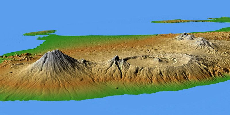
Original Caption Released with Image:
This perspective view shows the major volcanic group of Bali, one 13,000 islands comprising the nation of Indonesia. The conical mountain to the left is Gunung Agung, at 3,148 meters (10,308 feet) the highest point on Bali and an object of great significance in Balinese religion and culture. Agung underwent a major eruption in 1963 after more than 100 years of dormancy, resulting in the loss of over 1,000 lives.
In the center is the complex structure of Batur volcano, showing a caldera (volcanic crater) left over from a massive catastrophic eruption about 30,000 years ago. Judging from the total volume of the outer crater and the volcano, that once lay above it, approximately 140 cubic kilometers(33.4 cubic miles) of material must have been produced by this eruption, making it one of the largest known volcanic events on Earth. Batur is still active and has erupted at least 22 times since the 1800's.
Two visualization methods were combined to produce the image: shading and color coding of topographic height. The shade image was derived by computing topographic slope in the northwest-southeast direction, so that northwest slopes appear bright and southeast slopes appear dark. Color coding is directly related to topographic height, with green at the lower elevations, rising through yellow and tan, to white at the highest elevations.
Elevation data used in this image were acquired by the Shuttle Radar Topography Mission aboard the Space Shuttle Endeavour, launched on Feb. 11, 2000. SRTM used the same radar instrument that comprised the Spaceborne Imaging Radar-C/X-Band Synthetic Aperture Radar (SIR-C/X-SAR) that flew twice on the Space Shuttle Endeavour in 1994. SRTM was designed to collect 3-D measurements of the Earth's surface. To collect the 3-D data, engineers added a 60-meter (approximately 200-foot) mast, installed additional C-band and X-band antennas, and improved tracking and navigation devices. The mission is a cooperative project between NASA, the National Geospatial-Intelligence Agency (NGA) of the U.S. Department of Defense and the German and Italian space agencies. It is managed by NASA's Jet Propulsion Laboratory, Pasadena, Calif., for NASA's Earth Science Enterprise, Washington, D.C.
Location: 8.33 degrees South latitude, 115.17 degrees East longitude
Orientation: Looking southwest
Size: scale varies in this perspective image
Image Data: shaded and colored SRTM elevation model
Date Acquired: February 2000
Image Credit: NASA/JPL/NIMA
nb: Originally uploaded by me, Jack Merridew, as w:User:Davenbelle, on en:wp:
ファイルの履歴
過去の版のファイルを表示するには、その版の日時をクリックしてください。
| 日付と時刻 | サムネイル | 寸法 | 利用者 | コメント | |
|---|---|---|---|---|---|
| 現在の版 | 2005年6月28日 (火) 19:08 | | 1,400 × 704 (106キロバイト) | Igiveup | {{PD-USGov-NASA}} Source: [http://photojournal.jpl.nasa.gov/jpeg/PIA04951.jpg http://photojournal.jpl.nasa.gov/jpeg/PIA04951.jpg] |
ファイルの使用状況
グローバルなファイル使用状況
以下に挙げる他のウィキがこの画像を使っています:
- bg.wikipedia.org での使用状況
- bn.wikipedia.org での使用状況
- br.wikipedia.org での使用状況
- de.wikipedia.org での使用状況
- en.wikipedia.org での使用状況
- es.wikipedia.org での使用状況
- fr.wikipedia.org での使用状況
- he.wikipedia.org での使用状況
- hi.wikipedia.org での使用状況
- id.wikipedia.org での使用状況
- jv.wikipedia.org での使用状況
- ko.wikipedia.org での使用状況
- nl.wikipedia.org での使用状況
- oc.wikipedia.org での使用状況
- ru.wikipedia.org での使用状況
- ru.wikinews.org での使用状況
- simple.wikipedia.org での使用状況
- sl.wikipedia.org での使用状況
- su.wikipedia.org での使用状況
- uk.wikipedia.org での使用状況