
ファイル:AlgodonesDunes ISS011-E-11543.jpg

このプレビューのサイズ: 800 × 531 ピクセル。 その他の解像度: 320 × 212 ピクセル | 640 × 424 ピクセル | 1,024 × 679 ピクセル | 1,280 × 849 ピクセル | 3,040 × 2,016 ピクセル。
元のファイル (3,040 × 2,016 ピクセル、ファイルサイズ: 3.24メガバイト、MIME タイプ: image/jpeg)
ウィキメディア・コモンズのファイルページにある説明を、以下に表示します。
|
概要
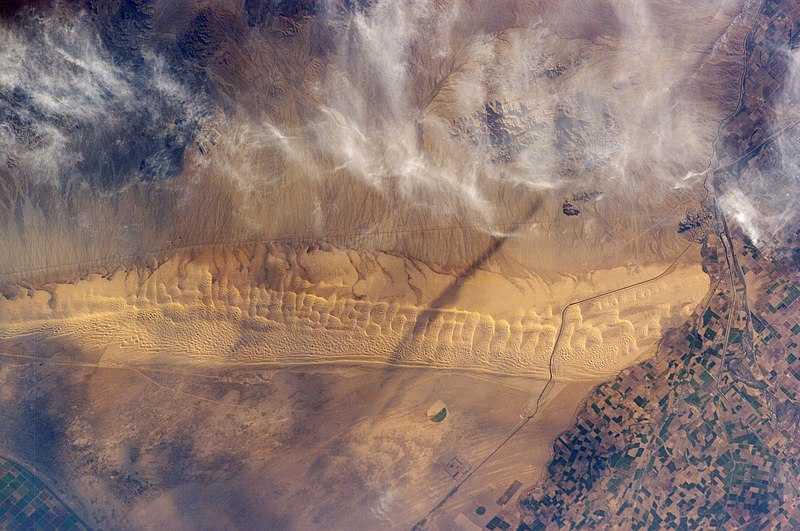
| 解説 | Astronaut photo of the Algodones Dunes, at the borders of California, Arizona, and Mexico. The All-American Canal cuts across the southern end of the dunes and the Cargo Muchacho Mountains can be seen beneath cloud cover at the top of the scene. Remains of the Alamo Canal are located parallel to the left side of the Colorado River (center far right of image), with the intake still visible near Pilot Knob. |
| 日付 | |
| 原典 | http://earthobservatory.nasa.gov/Newsroom/NewImages/images.php3?img_id=17098 |
| 作者 | ISS Crew Earth Observations experiment and the Image Science & Analysis Group, Johnson Space Center. Image cleaned up by NASA Earth Observatory |
| 許可 (ファイルの再利用) |
US government, public domain |
| カメラの位置 | | 以下のサービスでこの位置を確認する: オープンストリートマップ |
|---|
ライセンス
This file is in the public domain in the United States because it was created by the Image Science & Analysis Laboratory, of the NASA Johnson Space Center. NASA copyright policy states that "NASA material is not protected by copyright unless noted". (NASA media use guidelines or Conditions of Use of Astronaut Photographs).
Photo source: ISS011-E-11543.
|
| 注釈 | この画像には注釈がついています: コモンズで注釈を見る |
ファイルの履歴
過去の版のファイルを表示するには、その版の日時をクリックしてください。
| 日付と時刻 | サムネイル | 寸法 | 利用者 | コメント | |
|---|---|---|---|---|---|
| 現在の版 | 2013年5月25日 (土) 02:48 | | 3,040 × 2,016 (3.24メガバイト) | Ras67 | new rendered in high resolution from NASA's raw image data |
| 2006年5月1日 (月) 23:32 |  | 1,000 × 662 (459キロバイト) | Holly Cheng | {{Information | Description=Astronaut photo of the w:Algodones Dunes, at the borders of California, Arizona, and Mexico. The w:All-American Canal cuts across the southern end of the dunes and the w:Cargo Muchacho Mountains can be seen beneath |
ファイルの使用状況
以下のページがこのファイルを使用しています:
グローバルなファイル使用状況
以下に挙げる他のウィキがこの画像を使っています:
- arz.wikipedia.org での使用状況
- ceb.wikipedia.org での使用状況
- de.wikipedia.org での使用状況
- en.wikipedia.org での使用状況
- en.wikivoyage.org での使用状況
- es.wikipedia.org での使用状況
- fr.wikipedia.org での使用状況
- lld.wikipedia.org での使用状況
- sv.wikipedia.org での使用状況
- www.wikidata.org での使用状況