
ファイル:Switzerland (14399363612).jpg
元のファイル (3,032 × 1,998 ピクセル、ファイルサイズ: 1.53メガバイト、MIME タイプ: image/jpeg)
ウィキメディア・コモンズのファイルページにある説明を、以下に表示します。
|
.jpg?uselang=ja)
.jpg?uselang=ja)
.jpg?uselang=ja&action=history)
.jpg)
概要
| 解説 |
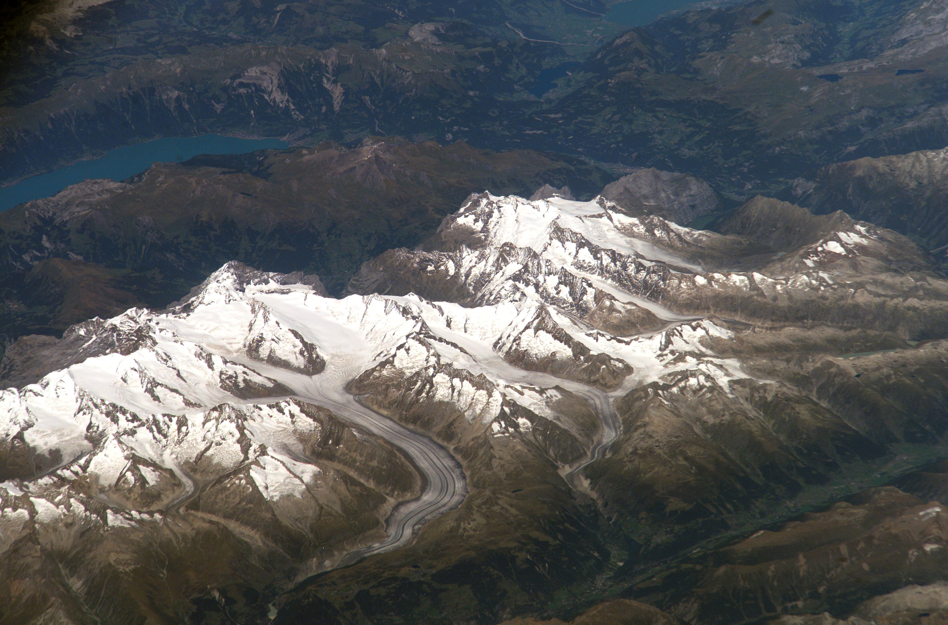
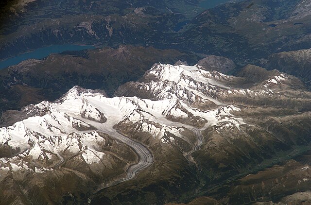
Bernese Alps, Switzerland Bernese Alps, Switzerland is featured in this image photographed by an Expedition 13 crewmember onboard the International Space Station. The formidable mountain system of the Alps stretches across much of central Europe, with seven countries claiming portions of the mountains within their borders (Germany, France, Switzerland, Italy, Liechtenstein, Austria, and Slovenia). The glacial landscape of the Bernese Alps, located in southwestern Switzerland, is well illustrated by this view. The image was taken by a crewmember looking north-northwest while the station was located over the Mediterranean Sea between Corsica and Italy -- this oblique viewing angle imparts a sense of perspective to the image. This type of viewing angle complements more nadir (downward)--viewing imagery of the region. Three of the higher peaks of the central Alps are visible--Jungfrau (4,158 meters), Moench (4,089 meters), and Eiger (3,970 meters). To the east and south of the Jungfrau is the Aletsch Glacier, clearly marked by dark medial moraines extending along the glacier's length parallel to the valley axis. The moraines are formed from rock and soil debris collected along the sides of three mountain glaciers located near the Jungfrau and Moench peaks -- as these flowing ice masses merge to form the Aletsch Glacier, the debris accumulates in the middle of the glacier and is carried along the flow direction. According to geologists, Lake Brienz to the northwest was formed by the actions of both glacial ice and the flowing waters of the Aare and Lutschine rivers, and has a maximum depth of 261 meters. The lake has a particularly fragile ecosystem, as demonstrated by the almost total collapse of the whitefish population in 1999. Possible causes for the collapse, according to the scientists, include increased water turbidity associated with upstream hydropower plant operations, and reduction of phosphorus (a key nutrient for lake algae, a basic element of the local food web) due to water quality concerns. Credit: NASA/ISS NASA Goddard Space Flight Center enables NASA’s mission through four scientific endeavors: Earth Science, Heliophysics, Solar System Exploration, and Astrophysics. Goddard plays a leading role in NASA’s accomplishments by contributing compelling scientific knowledge to advance the Agency’s mission. Follow us on Twitter Like us on Facebook Find us on Instagram |
| 日付 | |
| 原典 | Switzerland |
| 作者 | NASA Goddard Space Flight Center from Greenbelt, MD, USA |
ライセンス
- あなたは以下の条件に従う場合に限り、自由に
- 共有 – 本作品を複製、頒布、展示、実演できます。
- 再構成 – 二次的著作物を作成できます。
- あなたの従うべき条件は以下の通りです。
- 表示 – あなたは適切なクレジットを表示し、ライセンスへのリンクを提供し、変更があったらその旨を示さなければなりません。これらは合理的であればどのような方法で行っても構いませんが、許諾者があなたやあなたの利用行為を支持していると示唆するような方法は除きます。
| この画像は当初、NASA Goddard Photo and Video によって Flickr の https://flickr.com/photos/24662369@N07/14399363612 に投稿されたものです。2016-09-17、FlickreviewR ボットによってレビューされ、cc-by-2.0 のライセンスで提供されていることが確認されました。 |
| このファイルはアメリカ航空宇宙局(NASA)によって作成されたものです。NASAの著作権の方針では、特記事項が無い場合、NASAの資料はパブリックドメインとなります。 (詳しくはTemplate:PD-USGov、NASAの著作権の方針について(英語)又はジェット推進研究所(JPL)の画像使用に関するガイドライン(英語)をご覧ください。) |
||
 |
注意事項:
|
ファイルの履歴
過去の版のファイルを表示するには、その版の日時をクリックしてください。
| 日付と時刻 | サムネイル | 寸法 | 利用者 | コメント | |
|---|---|---|---|---|---|
| 現在の版 | 2016年9月17日 (土) 20:33 | | 3,032 × 1,998 (1.53メガバイト) | Vanished Account Byeznhpyxeuztibuo | Transferred from Flickr via Flickr2Commons |
ファイルの使用状況
グローバルなファイル使用状況
以下に挙げる他のウィキがこの画像を使っています:
- ca.wikipedia.org での使用状況
- en.wikipedia.org での使用状況
- he.wikipedia.org での使用状況
- ko.wikipedia.org での使用状況
- ru.wikipedia.org での使用状況
- sl.wikipedia.org での使用状況
- uk.wikipedia.org での使用状況
- zh.wikipedia.org での使用状況
.jpg)