
ファイル:1827 Finley Map of Vermont - Geographicus - Vermont-finely-1827.jpg

このプレビューのサイズ: 471 × 600 ピクセル。 その他の解像度: 188 × 240 ピクセル | 377 × 480 ピクセル | 603 × 768 ピクセル | 804 × 1,024 ピクセル | 2,356 × 3,000 ピクセル。
元のファイル (2,356 × 3,000 ピクセル、ファイルサイズ: 1.78メガバイト、MIME タイプ: image/jpeg)
ウィキメディア・コモンズのファイルページにある説明を、以下に表示します。
|
| Anthony Finley: Vermont.
( |
||||||
|---|---|---|---|---|---|---|
| 作者 | ||||||
| タイトル |
Vermont. |
|||||
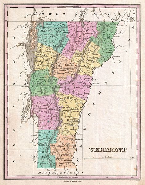
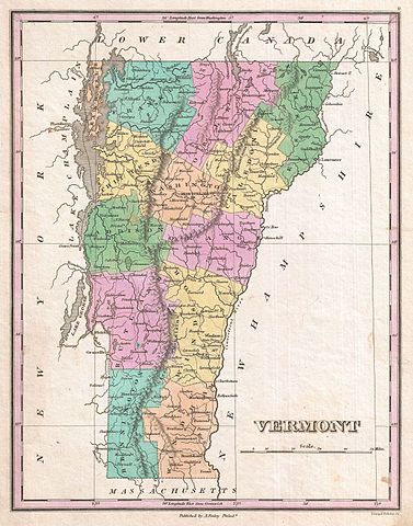
| 解説 |
English: A beautiful example of Finley's important 1827 map of Vermont. Depicts the state with moderate detail in Finley's classic minimalist style. Shows river ways, roads, canals, and some topographical features. Offers color coding at the county level. Title and scale in lower right quadrant. It is very uncommon to find an early 19th century exclusively depicting Vermont, as most maps of the period bundled it with New Hampshire. Identifies Killington Peak and Camel's Hump, now popular ski resorts. Engraved by Young and Delleker for the 1827 edition of Anthony Finley's General Atlas . |
|||||
| 日付 | 1827年 (undated) | |||||
| 寸法 | 高さ: 11.5 in (29.2 cm);幅: 9 in (22.8 cm) | |||||
| 台帳番号 |
Geographicus link: Vermont-finely-1827 |
|||||
| 情報源/撮影者 |
Finley, Anthony, A New General Altas, Comprising a Complete Set of Maps, representing the Grand Divisions of the Globe, Together with the several Empires, Kingdoms and States in the World; Compiled from the Best Authorities, and corrected by the Most Recent Discoveries, Philadelphia, 1827.
|
|||||
| 許可 (ファイルの再利用) |
|
|||||
ファイルの履歴
過去の版のファイルを表示するには、その版の日時をクリックしてください。
| 日付と時刻 | サムネイル | 寸法 | 利用者 | コメント | |
|---|---|---|---|---|---|
| 現在の版 | 2011年3月23日 (水) 08:55 | | 2,356 × 3,000 (1.78メガバイト) | BotMultichillT | {{subst:User:Multichill/Geographicus |link=http://www.geographicus.com/P/AntiqueMap/Vermont-finely-1827 |product_name=1827 Finley Map of Vermont |map_title=Vermont. |description=A beautiful example of Finley's important 1827 map of Vermont. Depicts the st |
ファイルの使用状況
以下のページがこのファイルを使用しています:
グローバルなファイル使用状況
以下に挙げる他のウィキがこの画像を使っています:
- bn.wikipedia.org での使用状況
- en.wikipedia.org での使用状況
- ko.wikipedia.org での使用状況
- uk.wikipedia.org での使用状況