
ファイル:Yoshiwara Map Edo by Utagawa Hiroshige II July 1860.png
このプレビューのサイズ: 800 × 407 ピクセル。 その他の解像度: 320 × 163 ピクセル | 640 × 326 ピクセル | 1,024 × 521 ピクセル | 1,280 × 652 ピクセル | 4,000 × 2,036 ピクセル。
元のファイル (4,000 × 2,036 ピクセル、ファイルサイズ: 14.58メガバイト、MIME タイプ: image/png)
ウィキメディア・コモンズのファイルページにある説明を、以下に表示します。
|
概要
| 解説 |
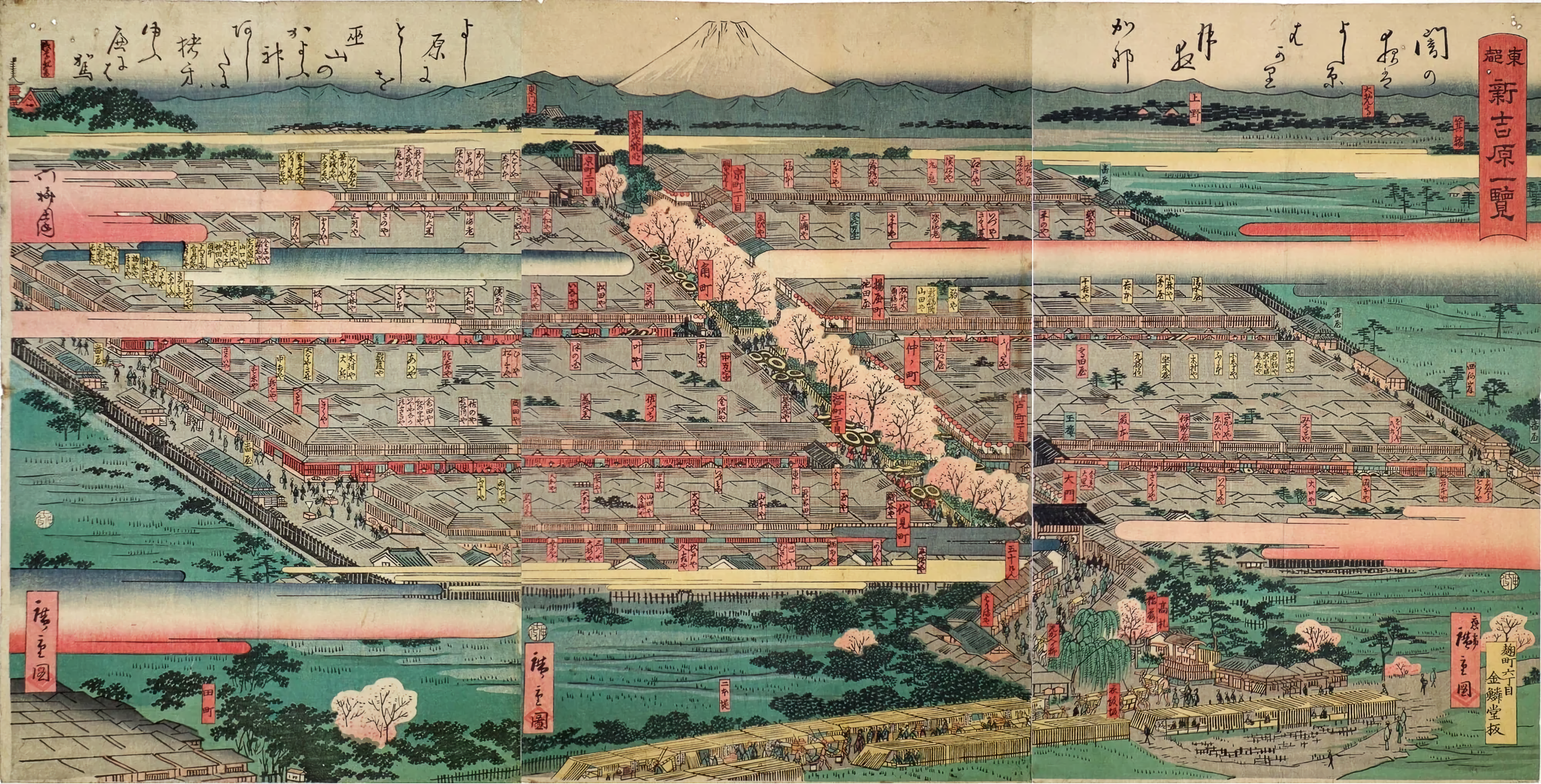
English: Yoshiwara red-light district before the advent of electricity in July 1860 (Edo period). This is Hiroshige Utagawa II's "Tōto Shin-Yoshiwara ichiran (View of Shin-Yoshiwara in the Eastern Capital). The Yoshiwara red-light district has a square shape and is surrounded by rice fields. If you look at the maps from that time, you'll understand. Yoshiwara Yukaku was a square, 330 meters wide and about 250 meters long. Literally "guo" = surrounded place. The Nakanochō main street, lined with cherry trees, had teahouses that mediated for the brothels. Although it is not clearly depicted in ukiyo-e, the Yoshiwara red-light district was surrounded by a wall, and outside of it was a moat with a width of more than 5 meters called “Oguro Dobu”. It was generally only accessible by a large central gate and by boat via the Sanya canal which was filled in long ago. The district's location corresponds to modern-day Senzoku 4-Chōme in Tokyo, Taitō-ku.
日本語: 二代歌川広重の「東都 新吉原一覧」です(1860年7月)。吉原遊郭は四角い形をしており、周囲は田んぼで囲まれています。当時の地図も見てみるとよく分かるかと思います。吉原遊郭は横が約330m、奥行きが約250m弱の四角い形をしていました。文字通り「郭」=囲まれた場所だったのです。浮世絵にはあまりはっきりとは描かれていませんが、吉原遊郭の周囲には塀が張り巡らされ、さらにその外には「お歯黒どぶ」と呼ばれる、5m以上も幅がある堀がありました。現在の東京都台東区千束4丁目にあたる。 |
| 日付 | |
| 原典 | Ota Memorial Museum of Art (太田記念美術館). See also: Tokyo Metropolitan Library - https://archive.library.metro.tokyo.lg.jp/da/detail?tilcod=0000000003-00226342 |
| 作者 | Utagawa Hiroshige II (1826-1869) |
ライセンス
|
このファイルは、パブリックドメインの状態にある平面的な美術の著作物を写真術によって忠実に複製したものです。このような複製はアメリカ合衆国においてパブリックドメインの状態にあります。その他の地域では再利用に制限がかかる場合があります。詳しくはReuse of PD-Art photographsをご覧ください。美術の著作物としての原図は、次の理由によりパブリックドメインの状態にあります。
| ||||
ファイルの履歴
過去の版のファイルを表示するには、その版の日時をクリックしてください。
| 日付と時刻 | サムネイル | 寸法 | 利用者 | コメント | |
|---|---|---|---|---|---|
| 現在の版 | 2022年12月30日 (金) 03:50 | | 4,000 × 2,036 (14.58メガバイト) | Artanisen | Uploaded a work by Utagawa Hiroshige II (1826-1869) from Ota Memorial Museum of Art (太田記念美術館) with UploadWizard |
ファイルの使用状況
以下のページがこのファイルを使用しています:
グローバルなファイル使用状況
以下に挙げる他のウィキがこの画像を使っています: