
ファイル:South lebanon Qana locator map.png

元のファイル (827 × 615 ピクセル、ファイルサイズ: 58キロバイト、MIME タイプ: image/png)
ウィキメディア・コモンズのファイルページにある説明を、以下に表示します。
|
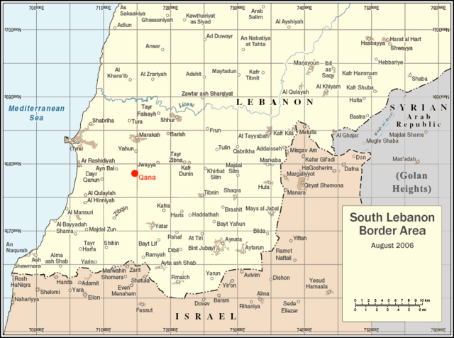
| 解説 | Locator map for Qana, Lebanon |
| 日付 | |
| 原典 | Uploaded as en:Image:South lebanon map qana.png on August 5 2006 |
| 作者 | Original map courtesy of the United Nations. Modifications by en:User:ChrisO. |
| 許可 (ファイルの再利用) |
PD |
| This image is a map derived from a United Nations map.
Unless stated otherwise, UN maps are to be considered in the public domain. This applies worldwide. UN maps are, in principle, open source material and you can use them in your work or for making your own map. UN requests however that you delete the UN name, logo and reference number upon any modification to the map. Content of your map will be your responsibility. You can state in your publication, if you wish, something like: based on UN map … (map name, map number, revision number and date). See: Geospatial Information Section. And: Geospatial, location data for a better world. |
 |
| |
このファイルは、ウィキメディア・コモンズ版プロジェクトにおいて、著作者であるChrisOによりその権利が放棄され、パブリックドメインの状態にあります。これは全世界で適用されます。 一部の国では、これが法的に可能ではない場合があります。その場合は、次のように宣言します。 ChrisOは、あらゆる人に対して、法により必要とされている条件を除き、如何なる条件も課すことなく、その目的を問わずこの著作物を利用する権利を与えます。 |
ファイルの履歴
過去の版のファイルを表示するには、その版の日時をクリックしてください。
| 日付と時刻 | サムネイル | 寸法 | 利用者 | コメント | |
|---|---|---|---|---|---|
| 現在の版 | 2006年8月8日 (火) 03:40 | | 827 × 615 (58キロバイト) | Jkelly | {{Information |Description=Locator map for Qana, Lebanon |Source=Uploaded as en:Image:South lebanon map qana.png on August 5 2006 |Date=August 5 2006 |Author=Original map courtesy of the United Nations. Modifications by [ |
ファイルの使用状況
以下のページがこのファイルを使用しています:
グローバルなファイル使用状況
以下に挙げる他のウィキがこの画像を使っています:
- ar.wikipedia.org での使用状況
- arz.wikipedia.org での使用状況
- ca.wikipedia.org での使用状況
- de.wikipedia.org での使用状況
- en.wikipedia.org での使用状況
- eo.wikipedia.org での使用状況
- es.wikipedia.org での使用状況
- fy.wikipedia.org での使用状況
- he.wikipedia.org での使用状況
- id.wikipedia.org での使用状況
- no.wikipedia.org での使用状況
- pl.wikipedia.org での使用状況
- tr.wikipedia.org での使用状況
- www.wikidata.org での使用状況