
ファイル:Radar loop of Typhoon Haiyan (Yolanda) making landfall on Leyte Island.gif
このプレビューのサイズ: 600 × 600 ピクセル。 その他の解像度: 240 × 240 ピクセル | 622 × 622 ピクセル。
元のファイル (622 × 622 ピクセル、ファイルサイズ: 1.13メガバイト、MIME タイプ: image/gif、ループします、19 フレーム、9.5秒)
ウィキメディア・コモンズのファイルページにある説明を、以下に表示します。
|
_making_landfall_on_Leyte_Island.gif?uselang=ja)
_making_landfall_on_Leyte_Island.gif?uselang=ja)
_making_landfall_on_Leyte_Island.gif?uselang=ja&action=history)
_making_landfall_on_Leyte_Island.gif)
概要
| 解説 |
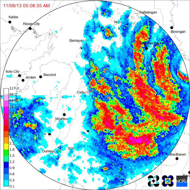
English: Loop of doppler radar imagery showing Typhoon Yolanda/Haiyan's second Philippine landfall, on the island of Leyte. The PAGASA Cebu City radar site began to transmit intermittently as the typhoon neared, eventually failing altogether (last frame).
|
| 日付 | |
| 原典 | http://www.pagasa.dost.gov.ph/ |
| 作者 | PAGASA |
ライセンス
| この著作物は、政府管轄又は管理された企業を含むフィリピン政府又はその下部組織及び機関の役員又は職員が、規則的に定められた公務の一環として作成した著作物であるため、フィリピンにおいてパブリックドメインの状態にあり、その他法域においても同様の状態にある可能性があります。従って、如何なる著作物も、別途註記しない限り、共和国法第8293号第4編第1章第171.11節及び第4章第4章第176節並びに改正共和国法第10372号の定めるところにより、著作権の目的となりません。但し、場合によっては、フィリピン等におけるこの著作物の使用について、本法律その他の法律で規制されている可能性があります。
|

|
ファイルの履歴
過去の版のファイルを表示するには、その版の日時をクリックしてください。
| 日付と時刻 | サムネイル | 寸法 | 利用者 | コメント | |
|---|---|---|---|---|---|
| 現在の版 | 2013年11月14日 (木) 10:40 | | 622 × 622 (1.13メガバイト) | Chilledsunshine | compressed to acceptable size |
| 2013年11月14日 (木) 09:36 |  | 600 × 600 (4.21メガバイト) | Chilledsunshine | User created page with UploadWizard |
ファイルの使用状況
以下のページがこのファイルを使用しています:
グローバルなファイル使用状況
以下に挙げる他のウィキがこの画像を使っています:
- de.wikipedia.org での使用状況
- en.wikipedia.org での使用状況
- tl.wikipedia.org での使用状況
- zh.wikipedia.org での使用状況
_making_landfall_on_Leyte_Island.gif)