
ファイル:DC neighborhoods map.png

このプレビューのサイズ: 526 × 599 ピクセル。 その他の解像度: 211 × 240 ピクセル | 421 × 480 ピクセル | 674 × 768 ピクセル | 899 × 1,024 ピクセル | 1,493 × 1,700 ピクセル。
元のファイル (1,493 × 1,700 ピクセル、ファイルサイズ: 1.52メガバイト、MIME タイプ: image/png)
ウィキメディア・コモンズのファイルページにある説明を、以下に表示します。
|
概要
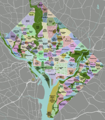
| 解説 | DC neighborhoods map |
| 日付 | |
| 原典 | self-made, tracing done from PD satellite imagery |
| 作者 | Peter Fitzgerald |
| 許可 (ファイルの再利用) |
CC-by 3.0 |
| その他のバージョン | SVG available on Wikitravel Shared, although it is not the current version, as Shared has a 8MB filesize limit... |
|
Need a higher resolution version? There's one available at File:DC neighborhoods map high res.png. (The thumbnail does not display images at such a high resolution—to access the file, click the "Full resolution" link [1] below the broken thumbnail.) |
![[1]](https://upload.wikimedia.org/wikipedia/commons/b/b8/DC_neighborhoods_map_high_res.png)
ライセンス
この作品の著作権者である私は、この作品を以下のライセンスで提供します。
このファイルはクリエイティブ・コモンズ 表示 3.0 非移植ライセンスのもとに利用を許諾されています。
- あなたは以下の条件に従う場合に限り、自由に
- 共有 – 本作品を複製、頒布、展示、実演できます。
- 再構成 – 二次的著作物を作成できます。
- あなたの従うべき条件は以下の通りです。
- 表示 – あなたは適切なクレジットを表示し、ライセンスへのリンクを提供し、変更があったらその旨を示さなければなりません。これらは合理的であればどのような方法で行っても構いませんが、許諾者があなたやあなたの利用行為を支持していると示唆するような方法は除きます。

|
このlocator map画像は、ベクターイメージである SVG ファイルとして再作成されるべきです。これにはいくつかの利点があります。詳しくはCommons:Media for cleanupを参照してください。この画像の SVG 形式がすでに利用可能である場合は、アップロードしてください。アップロード後、この画像にあるこのテンプレートを{{Vector version available|新しい画像ファイル名.svg}}テンプレートで置き換えてください。
|
ファイルの履歴
過去の版のファイルを表示するには、その版の日時をクリックしてください。
| 日付と時刻 | サムネイル | 寸法 | 利用者 | コメント | |
|---|---|---|---|---|---|
| 現在の版 | 2011年9月2日 (金) 02:21 | | 1,493 × 1,700 (1.52メガバイト) | Peterfitzgerald | minor change |
| 2011年9月2日 (金) 02:15 |  | 1,493 × 1,700 (1.52メガバイト) | Peterfitzgerald | Lots of corrections and refinements | |
| 2010年1月4日 (月) 20:53 |  | 1,493 × 1,700 (1.5メガバイト) | Peterfitzgerald | split off Kalorama Triangle from Adams Morgan, adjusted Fairlawn & Randall Heights boundaries, & split off Spring Valley from American University Park | |
| 2009年1月30日 (金) 21:45 |  | 1,493 × 1,700 (1.53メガバイト) | Peterfitzgerald | too high res, it would seem | |
| 2009年1月30日 (金) 21:39 |  | 4,390 × 5,000 (5.66メガバイト) | Peterfitzgerald | increase resolution | |
| 2008年9月4日 (木) 14:32 |  | 1,493 × 1,700 (1.53メガバイト) | Peterfitzgerald | increase font size for better in-article readability | |
| 2008年4月21日 (月) 02:33 |  | 1,493 × 1,700 (1.43メガバイト) | Peterfitzgerald | a few fixes | |
| 2008年4月14日 (月) 17:10 |  | 1,493 × 1,700 (1.46メガバイト) | Peterfitzgerald | Separate Burleith from Georgetown | |
| 2008年2月23日 (土) 02:37 |  | 1,493 × 1,700 (1.41メガバイト) | Peterfitzgerald | {{Information |Description=DC neighborhoods map |Source=self-made, tracing done from PD satellite imagery |Date=22 February 2008 |Author= Peter Fitzgerald |Permission=CC-by-SA 3.0 |other_versions=SVG available on [http://wikitrave |
ファイルの使用状況
このファイルを使用しているページはありません。
グローバルなファイル使用状況
以下に挙げる他のウィキがこの画像を使っています:
- de.wikipedia.org での使用状況
- en.wikipedia.org での使用状況
- en.wikivoyage.org での使用状況
- et.wikipedia.org での使用状況
- frr.wikipedia.org での使用状況
- ur.wikipedia.org での使用状況
- vi.wikipedia.org での使用状況