
ファイル:Auxiliary Latitudes Difference.svg

この SVG ファイルのこの PNG プレビューのサイズ: 540 × 360 ピクセル. その他の解像度: 320 × 213 ピクセル | 640 × 427 ピクセル | 1,024 × 683 ピクセル | 1,280 × 853 ピクセル | 2,560 × 1,707 ピクセル。
元のファイル (SVG ファイル、540 × 360 ピクセル、ファイルサイズ: 47キロバイト)
ウィキメディア・コモンズのファイルページにある説明を、以下に表示します。
|
概要
| 解説 |
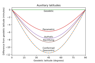
English: Graph of the difference between geodetic latitude and five auxiliary latitudes on the WGS 84 ellipsoid. Conformal and Geocentric are indistinguishable at this resolution. |
| 日付 | |
| 原典 | 投稿者自身による著作物 |
| 作者 | Apocheir |
| SVG 開発 | このW3C-無効 ベクター画像はMatplotlibで作成されました。 |
| ソースコード | Python codemport numpy as np
from scipy.special import ellipeinc
import matplotlib.pyplot as plt
f = 1/298.257223563
esq = f*(2-f)
e = np.sqrt(esq)
def gd(x):
return 2*np.arctan(np.tanh(x/2))
def gdinv(x):
return 2*np.arctanh(np.tan(x/2))
npts = 181
geodetic = np.linspace(0,np.pi/2,npts)
geocentric = np.arctan((1-f)**2 * np.tan(geodetic))
parametric = np.arctan((1-f) * np.tan(geodetic))
m = (ellipeinc(geodetic, esq) -
esq * np.sin(geodetic) * np.cos(geodetic) /
np.sqrt(1 - esq * np.sin(geodetic)**2))
rectifying = np.pi/2*m/m.max()
qp = 1 + (1-esq)/e*np.arctanh(e)
q = ((1 - esq)*np.sin(geodetic)/(1 - esq*np.sin(geodetic)**2) +
(1 - esq)/e*np.arctanh(e*np.sin(geodetic)))
authalic = np.arcsin(q/qp)
conformal = gd(gdinv(geodetic) - e * np.arctanh(e*np.sin(geodetic)))
gddegrees = np.linspace(0,90,npts)
gdmindiff = np.zeros(gddegrees.shape)
parmindiff = 10800/np.pi*(parametric - geodetic)
autmindiff = 10800/np.pi*(authalic - geodetic)
recmindiff = 10800/np.pi*(rectifying - geodetic)
conmindiff = 10800/np.pi*(conformal - geodetic)
gcmindiff = 10800/np.pi*(geocentric - geodetic)
fig = plt.figure()
ax = plt.axes()
#in this order so conformal and geocentric get contrasting colors
ax.plot(gddegrees, conmindiff, label='conformal', dashes=[4, 4])
ax.plot(gddegrees, gcmindiff, label='geocentric', dashes=[0, 4, 4, 0])
ax.plot(gddegrees, gdmindiff, label='geodetic')
ax.plot(gddegrees, parmindiff, label='parametric')
ax.plot(gddegrees, autmindiff, label='authalic')
ax.plot(gddegrees, recmindiff, label='rectifying')
bbox = dict(color='white', alpha=0)
ax.text(45, -0.1, 'Geodetic', bbox=bbox,
horizontalalignment='center', verticalalignment='top')
ax.text(45, min(parmindiff) + 0.2, 'Parametric', bbox=bbox,
horizontalalignment='center', verticalalignment='bottom')
ax.text(45, min(autmindiff) + 0.15, 'Authalic', bbox=bbox,
horizontalalignment='center', verticalalignment='bottom')
ax.text(45, min(recmindiff) + 0.25, 'Rectifying', bbox=bbox,
horizontalalignment='center', verticalalignment='bottom')
ax.text(45, min(gcmindiff) + 0.35, 'Conformal/\nGeocentric', bbox=bbox,
horizontalalignment='center', verticalalignment='bottom')
ax.set(xlim=(0, 90),
xlabel='Geodetic latitude (degrees)',
ylabel='Difference from geodetic latitude (minutes)',
title='Auxiliary latitudes');
ax.xaxis.set_major_locator(plt.MaxNLocator(7))
plt.savefig("Auxiliary Latitudes Difference.svg")
|
ライセンス
この作品の著作権者である私は、この作品を以下のライセンスで提供します。
| このファイルはクリエイティブ・コモンズ CC0 1.0 全世界 パブリック・ドメイン提供のもとで利用可能にされています。 | |
| ある作品に本コモンズ証を関連づけた者は、その作品について世界全地域において著作権法上認められる、その者が持つすべての権利(その作品に関する権利や隣接する権利を含む。)を、法令上認められる最大限の範囲で放棄して、パブリック・ドメインに提供しています。
この作品は、たとえ営利目的であっても、許可を得ずに複製、改変・翻案、配布、上演・演奏することが出来ます。 |
ファイルの履歴
過去の版のファイルを表示するには、その版の日時をクリックしてください。
| 日付と時刻 | サムネイル | 寸法 | 利用者 | コメント | |
|---|---|---|---|---|---|
| 現在の版 | 2019年9月5日 (木) 23:24 | | 540 × 360 (47キロバイト) | Apocheir | User created page with UploadWizard |
ファイルの使用状況
以下のページがこのファイルを使用しています: