
ファイル:Watkins Glen International Track Map.svg

この SVG ファイルのこの PNG プレビューのサイズ: 450 × 229 ピクセル. その他の解像度: 320 × 163 ピクセル | 640 × 326 ピクセル | 1,024 × 521 ピクセル | 1,280 × 651 ピクセル | 2,560 × 1,303 ピクセル。
元のファイル (SVG ファイル、450 × 229 ピクセル、ファイルサイズ: 60キロバイト)
ウィキメディア・コモンズのファイルページにある説明を、以下に表示します。
|
概要
| 解説 |
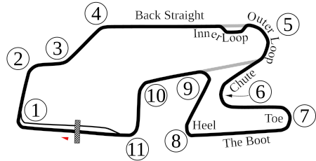
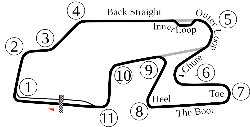
English: Vectorized old version of Image:Watkins Glen International Circuit Map.png. New version also adds the bus stop. |
| 日付 | 6-5-2008 |
| 原典 | 投稿者自身による著作物 |
| 作者 | Will Pittenger |
| その他のバージョン |
 |
| カメラの位置 | | 以下のサービスでこの位置を確認する: オープンストリートマップ |
|---|
ライセンス
| この著作物の著作権者である私は、この著作物における権利を放棄しパブリックドメインとします。これは全世界で適用されます。 一部の国では、これが法的に可能ではない場合があります。その場合は、次のように宣言します。 私は、あらゆる人に対して、法により必要とされている条件を除き、如何なる条件も課すことなく、あらゆる目的のためにこの著作物を使用する権利を与えます。 |
ファイルの履歴
過去の版のファイルを表示するには、その版の日時をクリックしてください。
| 日付と時刻 | サムネイル | 寸法 | 利用者 | コメント | |
|---|---|---|---|---|---|
| 現在の版 | 2009年10月15日 (木) 22:33 | | 450 × 229 (60キロバイト) | Spyder Monkey | Corrected corner numbers, converted text into paths for thumbnail display |
| 2009年10月15日 (木) 22:26 |  | 450 × 229 (37キロバイト) | Spyder Monkey | corrected corner names (inner loop, outer loop); added "Heel" of the boot | |
| 2008年6月6日 (金) 05:29 |  | 450 × 229 (77キロバイト) | Will Pittenger | Updated version that displays the text on paths that were supposed to be there. If you need to edit that text, please edit the older version. | |
| 2008年6月6日 (金) 05:22 |  | 450 × 229 (36キロバイト) | Will Pittenger | {{Information |Description={{en|1=Vectorized old version of Image:Watkins Glen International Circuit Map.png. New version also adds the bus stop.}} |Source=Own work by uploader |Author=Will Pittenger |Date=6-5-2008 |Permissio |
ファイルの使用状況
以下のページがこのファイルを使用しています:
グローバルなファイル使用状況
以下に挙げる他のウィキがこの画像を使っています:
- af.wikipedia.org での使用状況
- ast.wikipedia.org での使用状況
- bn.wikipedia.org での使用状況
- de.wikipedia.org での使用状況
- en.wikipedia.org での使用状況
- Watkins Glen International
- 1999 FIA GT Watkins Glen 3 Hours
- 2007 Camping World Watkins Glen Grand Prix
- 6 Hours of Watkins Glen
- 2008 Camping World Indy Grand Prix at the Glen
- 2009 Camping World Grand Prix at the Glen
- List of IMSA GT Championship circuits
- 2009 Six Hours of Watkins Glen
- 2009 Crown Royal 200 at the Glen
- List of IndyCar Series racetracks
- Crown Royal 200 at the Glen
- 2010 Camping World Grand Prix at The Glen
- List of GT World Challenge America circuits
- 2016 IndyCar Grand Prix at The Glen
- 2017 IndyCar Grand Prix at The Glen
- List of IMSA SportsCar Championship circuits
- 2019 6 Hours of The Glen
- 2017 6 Hours of The Glen
- 2021 6 Hours of The Glen
- 2021 WeatherTech 240 at The Glen
- 2022 Sahlen's Six Hours of The Glen
- 2018 6 Hours of The Glen
- 2023 Sahlen's Six Hours of The Glen
- es.wikipedia.org での使用状況
- eu.wikipedia.org での使用状況
- fa.wikipedia.org での使用状況
- fi.wikipedia.org での使用状況
- fr.wikipedia.org での使用状況
- hr.wikipedia.org での使用状況
- hu.wikipedia.org での使用状況
- id.wikipedia.org での使用状況
このファイルのグローバル使用状況を表示する。