
ファイル:Syrtis-Isidis zoom 64 pano.jpg

このプレビューのサイズ: 800 × 556 ピクセル。 その他の解像度: 320 × 222 ピクセル | 640 × 444 ピクセル | 1,024 × 711 ピクセル | 1,280 × 889 ピクセル | 2,560 × 1,778 ピクセル | 3,600 × 2,500 ピクセル。
元のファイル (3,600 × 2,500 ピクセル、ファイルサイズ: 4.28メガバイト、MIME タイプ: image/jpeg)
ウィキメディア・コモンズのファイルページにある説明を、以下に表示します。
|
概要
| 解説 |
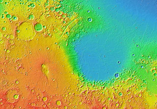
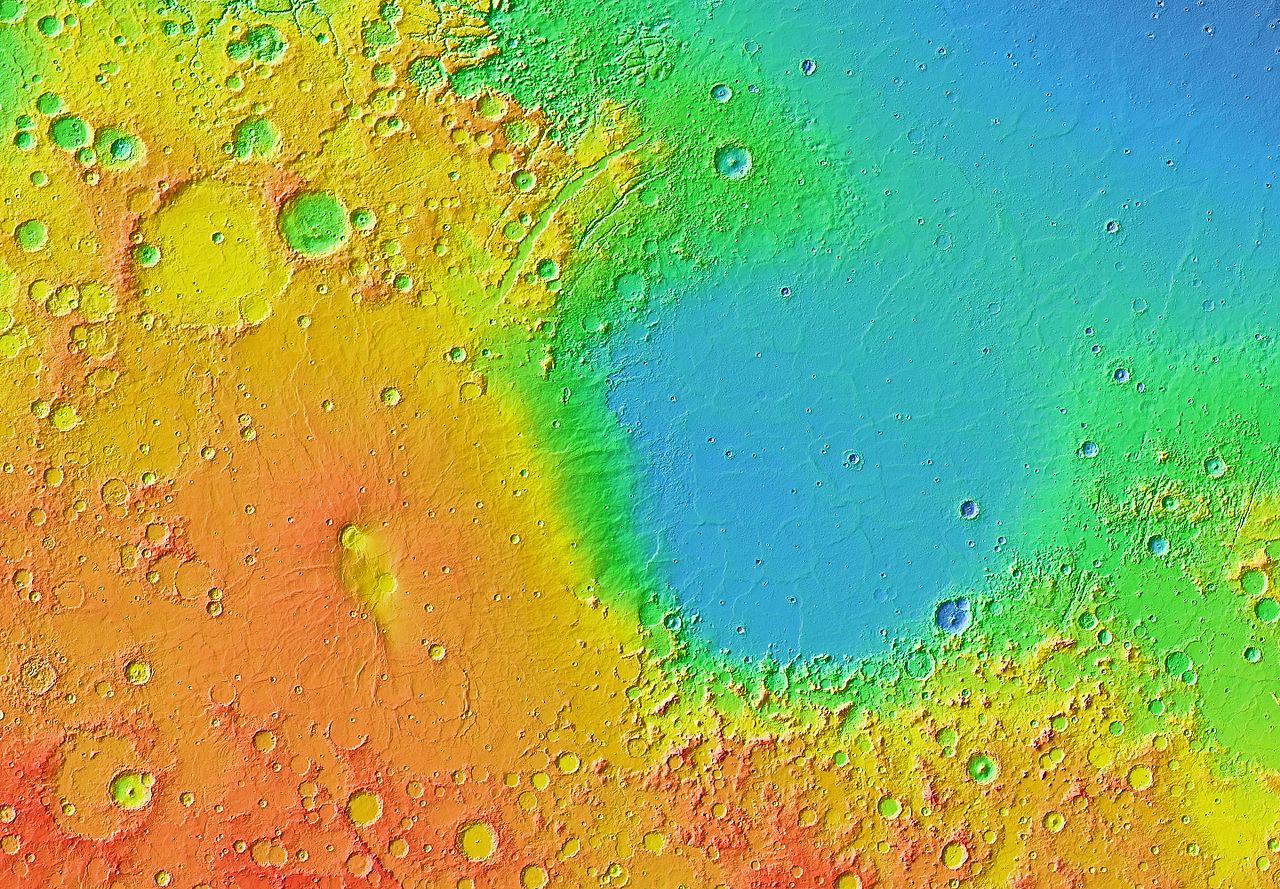
English: Mars Orbiter Laser Altimeter (MOLA) colorized topographic map showing the impact basin Isidis Planitia (right) and the broad, low-lying shield volcano Syrtis Major Planum (left), just north of the equator in the eastern hemisphere of Mars. Isidis is the third largest of the obvious impact basins on the planet. The calderas Nili Patera (upper left) and Meroe Patera (lower right) are visible within the central region of Syrtis Major. Some of the features in this image are annotated in Wikimedia Commons. |
| 日付 | |
| 原典 | JMARS |
| 作者 | NASA / JPL-Caltech / Arizona State University |
| その他のバージョン |
 |
ライセンス
| このファイルはアメリカ航空宇宙局(NASA)によって作成されたものです。NASAの著作権の方針では、特記事項が無い場合、NASAの資料はパブリックドメインとなります。 (詳しくはTemplate:PD-USGov、NASAの著作権の方針について(英語)又はジェット推進研究所(JPL)の画像使用に関するガイドライン(英語)をご覧ください。) |
||
 |
注意事項:
|
| 注釈 | この画像には注釈がついています: コモンズで注釈を見る |
ファイルの履歴
過去の版のファイルを表示するには、その版の日時をクリックしてください。
| 日付と時刻 | サムネイル | 寸法 | 利用者 | コメント | |
|---|---|---|---|---|---|
| 現在の版 | 2013年3月30日 (土) 07:04 | | 3,600 × 2,500 (4.28メガバイト) | WolfmanSF | User created page with UploadWizard |
ファイルの使用状況
以下のページがこのファイルを使用しています:
グローバルなファイル使用状況
以下に挙げる他のウィキがこの画像を使っています:
- ca.wikipedia.org での使用状況
- el.wikipedia.org での使用状況
- en.wikipedia.org での使用状況
- eo.wikipedia.org での使用状況
- fr.wikipedia.org での使用状況
- it.wikipedia.org での使用状況
- uk.wikipedia.org での使用状況