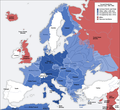
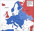
ファイル:Second world war europe 1941-1942 map en.png

ページのコンテンツが他言語でサポートされていません。

元のファイル(1,090 × 1,000 ピクセル、ファイルサイズ: 216キロバイト、MIME タイプ: image/png)

このmilitary map画像は、ベクターイメージである SVG ファイルとして再作成されるべきです。これにはいくつかの利点があります。詳しくはCommons:Media for cleanupを参照してください。この画像の SVG 形式がすでに利用可能である場合は、アップロードしてください。アップロード後、この画像にあるこのテンプレートを{{Vector version available|新しい画像ファイル名.svg}}テンプレートで置き換えてください。
Maps of the history of Europe
BCE
aC

Weichselian ice age (c. 113,000–9700) · Neolithic expansion (c. 7000–4500) · Middle Neolithic (c. 4500–4000) · Late Neolithic (c. 4000–3000) · Copper Age – Corded Ware culture (c. 2900–2350) · Copper Age – Bellbeaker culture (c. 2800–1800) · Early Bronze Age – Unetice culture (c. 2300–1600) · Late Bronze Age – Urnfield culture (c. 1300—750) · Migrations (c. 1000–100) · Hallstatt & La Tène cultures (c. 800–100) · Roman Republic (510–40) · 220 · 218 · 200 · 201–100 · 58 · 49 · 39 · 30 BCE–6 CE


CE
dC

14 · 14–37 · 60 · 60 · 69 · 80 · Migrations 100–500 · 117 · 117 · 125 · Migrations 150–774 · Economy 180 · 271 · 293–305 · 337 · 395 · c. 395 · 400 · 400 · 450 · 457–61 · 476 · 480 · Franks 481–814 · Early Slavs 500–700 · 500 · 526 · 526–600 · Christianisation to 600 · c. 550 · 650 · Pontic Steppe 650 · 665 · 800 · Vikings 800–1050 · 814 · 843–70 · 850 · 900 · 912 · 998 · 1000 · 1000 · 1054 · 1092 · First Crusade 1095–99 · 1097 · 1135 · 1142 · 1147–49 · 1190 · 1190 · 1250 · c. 1250 · 1301-1400 · 1301-1400 · 1328 · 1345 · Black Plague 1347–51 · 1360 · 1400 · Trade routes c. 1400 · 1430 · 1470 · 1490 · 1492 · 1500 · 1519 · 1550 · 1560 · Religion 1560 · Religion 1600 · Religion 1618 · 1618–48 · 1648 · 1683 · 1700 · 1701 · 1708 · 1714 · 1721 · 1725–30 · 1739–1740 · 1740 · 1748–66 · 1783–1792 · 1787 · 1787 · 1789 · 1799 · 1812 · 1812 · 1812 · 1812 · 1813 · 1815 · 1815 · 1815 · 1818 · Ottoman Empire 1830–1923 · 1848–49 · 1861 · 1867 · 1871 · 1878 · 1890 · 1905 · 1911 · 1914 · 1914 · 1919 · 1919–29 · 1923 · 1929 · 1930 · 1940 · 1941–42 · 1942–45 · Cold War 1947–91 · 1950 · 1993–2006 · 2006 to date

(this template: · view · discuss )

概要

注釈
InfoField
この画像には注釈がついています: コモンズで注釈を見る
解説
Deutsch: Karte der vom Deutschen Reich besetzten Gebiete und der Kriegsfronten im Zweiten Weltkrieg, 1941/42.
English: A map of German front of the Second World War circa 1941-1942.
Ελληνικά: Εδαφικές κατακτήσεις του Ράιχ
Español: Conquistas territoriales del Reich
日付 Original Image: 17 April 2005
Derivative Image: 22 December 2005
原典 このファイルの派生元: Second world war europe 1941-1942 map de.png
作者 Original Author: User:San Jose
Derivative Author: User:ArmadniGeneral
許可
(ファイルの再利用)
This image is a translation of the original, created and released under the terms of the GNU Free Documentation License.
その他のバージョン

このファイルの派生的著作物:  Großdeutsches Reich-europe.png [編集]

ライセンス

GNU head この文書は、フリーソフトウェア財団発行のGNUフリー文書利用許諾書 (GNU Free Documentation License) 1.2またはそれ以降のバージョンの規約に基づき、複製や再配布、改変が許可されます。不可変更部分、表紙、背表紙はありません。このライセンスの複製は、GNUフリー文書利用許諾書という章に含まれています。
w:ja:クリエイティブ・コモンズ
表示 継承
このファイルはクリエイティブ・コモンズ 表示-継承 3.0 非移植ライセンスのもとに利用を許諾されています。
あなたは以下の条件に従う場合に限り、自由に
  • 共有 – 本作品を複製、頒布、展示、実演できます。
  • 再構成 – 二次的著作物を作成できます。
あなたの従うべき条件は以下の通りです。
  • 表示 – あなたは適切なクレジットを表示し、ライセンスへのリンクを提供し、変更があったらその旨を示さなければなりません。これらは合理的であればどのような方法で行っても構いませんが、許諾者があなたやあなたの利用行為を支持していると示唆するような方法は除きます。
  • 継承 – もしあなたがこの作品をリミックスしたり、改変したり、加工した場合には、あなたはあなたの貢献部分を元の作品とこれと同一または互換性があるライセンスの下に頒布しなければなりません。
このライセンスのテンプレートは、GFDLのライセンス・アップデートによりこのファイルに追加されたものです。

キャプション

このファイルの内容を1行で記述してください
This map represents Europe in 1941-1942

このファイルに描写されている項目

題材

ファイルの履歴

過去の版のファイルを表示するには、その版の日時をクリックしてください。

日付と時刻サムネイル寸法利用者コメント
現在の版2020年8月5日 (水) 16:202020年8月5日 (水) 16:20時点における版のサムネイル1,090 × 1,000 (216キロバイト)Claude ZygielDistinguished statutes
2018年7月28日 (土) 01:002018年7月28日 (土) 01:00時点における版のサムネイル1,090 × 1,000 (184キロバイト)JeffyPShrinking file size
2009年2月16日 (月) 08:062009年2月16日 (月) 08:06時点における版のサムネイル1,090 × 1,000 (214キロバイト)Guinnog{{Information |Description=better titles |Source=*File:Second_world_war_europe_1941-1942_map_en.png |Date=2009-02-16 08:05 (UTC) |Author=*File:Second_world_war_europe_1941-1942_map_en.png: Sir Lothar *derivative work: ~~~ |Permission=see below
2008年4月11日 (金) 00:222008年4月11日 (金) 00:22時点における版のサムネイル1,090 × 1,000 (208キロバイト)Sir Lothar
2005年12月21日 (水) 05:362005年12月21日 (水) 05:36時点における版のサムネイル1,090 × 1,000 (221キロバイト)ArmadniGeneralA map of the Eastern front of the Second World War circa 1941-1942. The original German-language map was created by User:San Jose on 17 April 2005. It can be found here: Image:Second world war europe 1941-1942 map de.png. This image is a translat

以下の​ 2 ページがこのファイルを使用しています:

グローバルなファイル使用状況

以下に挙げる他のウィキがこの画像を使っています:

このファイルのグローバル使用状況を表示する。

メタデータ