
ファイル:Partition of Hungary.png
高解像度版はありません。
Partition_of_Hungary.png (389 × 328 ピクセル、ファイルサイズ: 31キロバイト、MIME タイプ: image/png)
ウィキメディア・コモンズのファイルページにある説明を、以下に表示します。
|
概要

| 解説 |
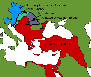
A map displaying position of the Kingdom of Hungary before 1541, and the 3 parts into which it was divided after the occupation of Buda in 1541: Royal Hungary, Eastern Hungarian kingdom, and the part that was annexed by the Ottoman Empire. en:Category:Maps of the history of Hungary |
| 日付 | 2006年9月3日 (当初のアップロード日) |
| 原典 | en.wikipedia からコモンズに移動されました。 |
| 作者 | Later versions were uploaded by PANONIAN, DonatusHR at en.wikipedia. |
ライセンス
| この著作物は、著作者である英語版ウィキペディアのEsoltasさんによって権利が放棄され、パブリックドメインとされました。これは全世界で適用されます。 一部の国では、これが法的に可能ではない場合があります。その場合は、次のように宣言します。 Esoltasは、あらゆる人に対して、法により必要とされている条件を除き、如何なる条件も課すことなく、あらゆる目的のためにこの著作物を使用する権利を与えます。 |
元のアップロードログ
元のファイルページはこちら。以下の利用者は全てen.wikipediaに属します。
- 2007-08-12 15:14 DonatusHR 389×328×8 (38357 bytes) Vraćeno na prijašnju inačicu
- 2007-08-12 15:13 DonatusHR 389×328×8 (35596 bytes) Vraćeno na prijašnju inačicu
- 2006-10-11 10:58 PANONIAN 389×328×8 (38357 bytes) corrected image
- 2006-09-03 15:00 Esoltas 389×328×8 (35596 bytes) A map displaying the original position of the Kingdom of Hungary, and the 3 lands that became of it after the Battle of Mohács: Royal Hungary, Transylvania, and the Ottoman-occupied section.
ファイルの履歴
過去の版のファイルを表示するには、その版の日時をクリックしてください。
| 日付と時刻 | サムネイル | 寸法 | 利用者 | コメント | |
|---|---|---|---|---|---|
| 現在の版 | 2016年2月12日 (金) 17:22 | | 389 × 328 (31キロバイト) | Packare | better caption |
| 2007年9月10日 (月) 17:58 |  | 389 × 328 (37キロバイト) | Sir Iain | {{Information |Description=A map displaying position of the Kingdom of Hungary before 1526, and the 3 parts into which it was divided after the Battle of Mohács: Royal Hungary, Transylvania, and the part that was annexed by the Ottoman Empire. [[:en:Ca |
ファイルの使用状況
以下のページがこのファイルを使用しています:
グローバルなファイル使用状況
以下に挙げる他のウィキがこの画像を使っています:
- ar.wikipedia.org での使用状況
- azb.wikipedia.org での使用状況
- de.wikipedia.org での使用状況
- el.wikipedia.org での使用状況
- en.wikipedia.org での使用状況
- es.wikipedia.org での使用状況
- fr.wikipedia.org での使用状況
- gl.wikipedia.org での使用状況
- hu.wikipedia.org での使用状況
- io.wikipedia.org での使用状況
- it.wikipedia.org での使用状況
- ko.wikipedia.org での使用状況
- lv.wikipedia.org での使用状況
- nl.wikipedia.org での使用状況
- sk.wikipedia.org での使用状況
- trv.wikipedia.org での使用状況
- tr.wikipedia.org での使用状況
- uk.wikipedia.org での使用状況
- uz.wikipedia.org での使用状況
- zh.wikipedia.org での使用状況