ファイル:Nile River and delta from orbit.jpg

ページのコンテンツが他言語でサポートされていません。

Nile_River_and_delta_from_orbit.jpg(700 × 550 ピクセル、ファイルサイズ: 85キロバイト、MIME タイプ: image/jpeg)

概要

解説

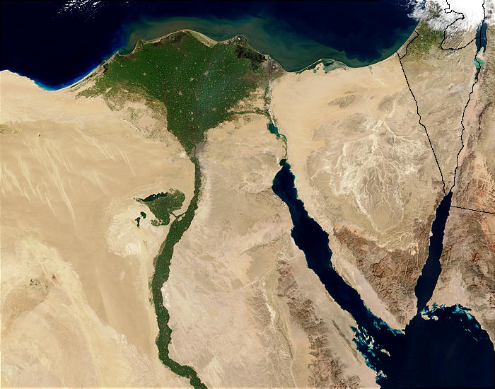
Nile River and delta from orbit Description: The Nile River and delta as seen from space by the MODIS sensor on the Terra satellite.

"Against the barren desert of northeastern Africa, the fertile valley of the Nile River runs northward through Egypt. In the higher-resolution images, the city of Cairo can be seen as a gray smudge right where the river widens into its broad fan-shaped delta. Other cities are dotted across the green landscape, giving it a speckled appearance. Where the Nile empties into the Mediterranean Sea (top) the waters are swirling with color, likely a mixture of sediment, organic matter, and possibly marine plant life. Farther west, the bright blue color of the water is likely less-organically rich sediment, perhaps sand.
"East of the delta lies the arid Sinai Peninsula, whose pointed tip is home to rugged mountains, some as high as 8,600 feet. The lattice work of pale lines marks the paths of ephemeral rivers. The Sinai Peninsula intrudes into the Red Sea. Farther east are Israel, Jordan, and Saudi Arabia. At top right is the disputed territory of the West Bank.
"In the false-color image, vegetation is bright green, water is dark blue or black, and clouds are light blue. It's interesting to notice that places that seem essentially arid, or desert-like in the true-color image in fact have a delicate layer of vegetation. For example, the central Sinai Peninsula, and most of Israel have a faint greenish tinge in the false-color images.
日付
原典 http://visibleearth.nasa.gov/view_rec.php?id=4927 [1]
作者 Jacques Descloitres, MODIS Rapid Response Team, NASA/sh
その他のバージョン Cuaggjacgacugvajgca

Salchicha

ライセンス

Public domain このファイルはアメリカ航空宇宙局(NASA)によって作成されたものです。NASAの著作権の方針では、特記事項が無い場合、NASAの資料はパブリックドメインとなります。
(詳しくはTemplate:PD-USGovNASAの著作権の方針について(英語)又はジェット推進研究所(JPL)の画像使用に関するガイドライン(英語)をご覧ください。)
注意事項:

キャプション

このファイルの内容を1行で記述してください
Nile delta

このファイルに描写されている項目

題材

5 2 2003

ファイルの履歴

過去の版のファイルを表示するには、その版の日時をクリックしてください。

日付と時刻サムネイル寸法利用者コメント
現在の版2004年11月29日 (月) 22:472004年11月29日 (月) 22:47時点における版のサムネイル700 × 550 (85キロバイト)MschlindweinNile River and delta from orbit

以下の​ 3 ページがこのファイルを使用しています:

グローバルなファイル使用状況

以下に挙げる他のウィキがこの画像を使っています:

このファイルのグローバル使用状況を表示する。