
ファイル:Nelson Mandela Bay 2011 population density map.svg

この SVG ファイルのこの PNG プレビューのサイズ: 666 × 600 ピクセル. その他の解像度: 267 × 240 ピクセル | 533 × 480 ピクセル | 853 × 768 ピクセル | 1,137 × 1,024 ピクセル | 2,275 × 2,048 ピクセル | 913 × 822 ピクセル。
元のファイル (SVG ファイル、913 × 822 ピクセル、ファイルサイズ: 157キロバイト)
ウィキメディア・コモンズのファイルページにある説明を、以下に表示します。
|
概要
| 解説 |
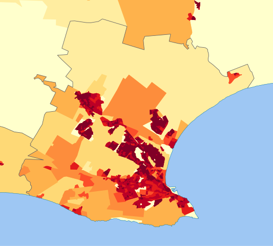
English: Population density map of the Nelson Mandela Bay Metro, Eastern Cape, South Africa, from the 2011 Census, at the "Small Area" level.
<1 inhabitant/km²
1–3 inhabitants/km²
3–10 inhabitants/km²
10–30 inhabitants/km²
30–100 inhabitants/km²
100–300 inhabitants/km²
300–1000 inhabitants/km²
1000–3000 inhabitants/km²
>3000 inhabitants/km² |
| 日付 | |
| 原典 | Statistics South Africa's Census 2011 is the source of the basic population data. The map results from my own processing of the data. |
| 作者 | Htonl |
| 許可 (ファイルの再利用) |
http://beta2.statssa.gov.za/?page_id=425 |
ライセンス
The following license applies to the population data on which the map is based:

|
このファイルの著作権者Statistics South Africa (States SA)は、あらゆる人があらゆる目的でこのファイルを使用することを許可しています。ただし著作権者の名義が適切に表示されることを条件とします。再頒布、二次的著作物の製作、商用利用等のあらゆる使用が許可されています。 |
帰属:
Statistics South Africa (States SA)
|
The following tag applies to the map itself:
| この著作物の著作権者である私は、この著作物における権利を放棄しパブリックドメインとします。これは全世界で適用されます。 一部の国では、これが法的に可能ではない場合があります。その場合は、次のように宣言します。 私は、あらゆる人に対して、法により必要とされている条件を除き、如何なる条件も課すことなく、あらゆる目的のためにこの著作物を使用する権利を与えます。 |
ファイルの履歴
過去の版のファイルを表示するには、その版の日時をクリックしてください。
| 日付と時刻 | サムネイル | 寸法 | 利用者 | コメント | |
|---|---|---|---|---|---|
| 現在の版 | 2013年10月13日 (日) 14:30 | | 913 × 822 (157キロバイト) | Htonl | == {{int:filedesc}} == {{Information |Description={{en|1=Population density map of the Nelson Mandela Bay Metro, Eastern Cape, South Africa, from the 2011 Census, at the "Small Area" level. {{legend|#ffffcc|<1 inhabitant/km²}} {{legend|#ffeda0|1–... |
ファイルの使用状況
以下のページがこのファイルを使用しています:
グローバルなファイル使用状況
以下に挙げる他のウィキがこの画像を使っています:
- en.wikipedia.org での使用状況
- vi.wikipedia.org での使用状況
- zh.wikipedia.org での使用状況