
ファイル:Nantucket NM23-744-635.jpg
元のファイル (4,024 × 4,024 ピクセル、ファイルサイズ: 13.64メガバイト、MIME タイプ: image/jpeg)
ウィキメディア・コモンズのファイルページにある説明を、以下に表示します。
|
概要
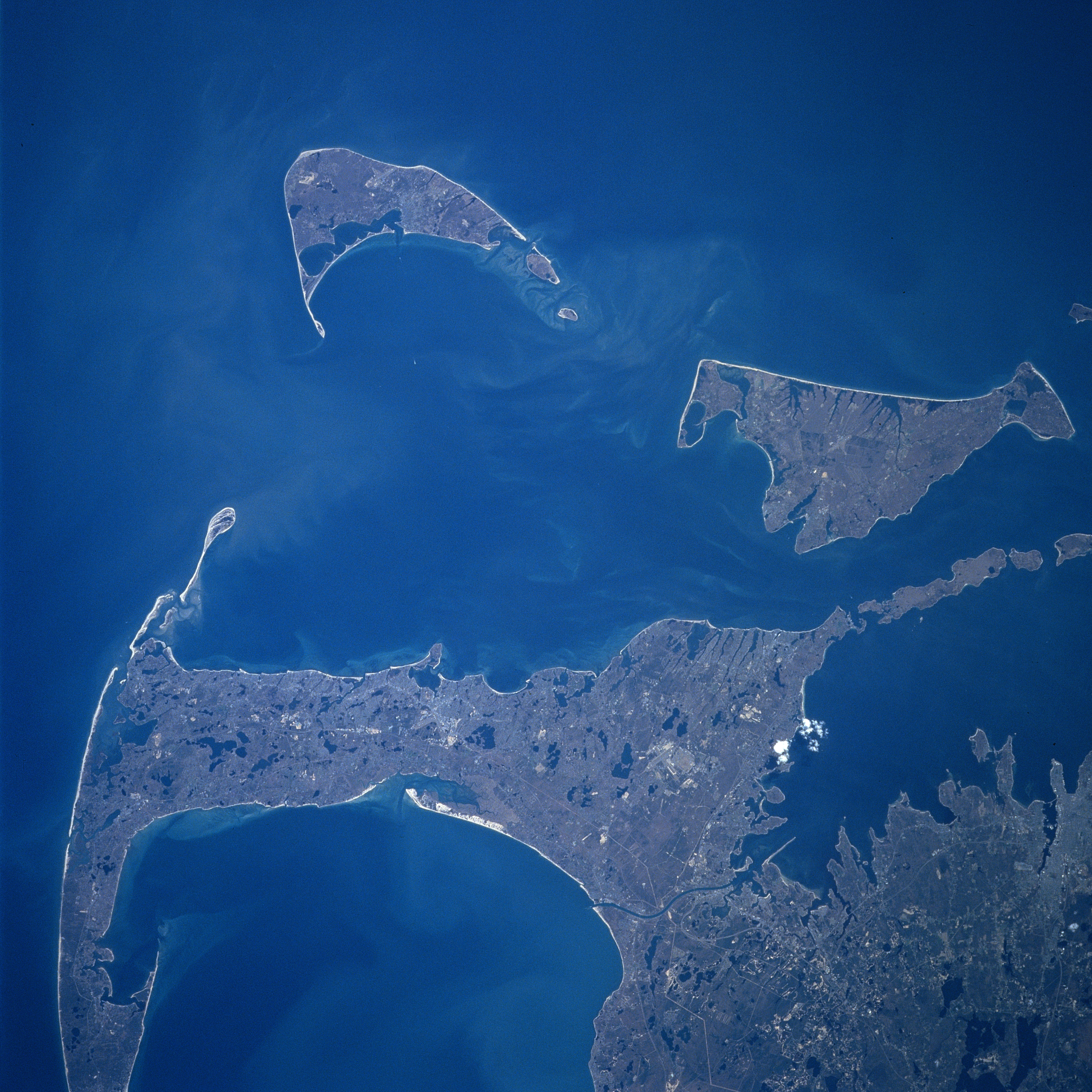
Cape Cod, Nantucket and Marthas Vineyard Islands, Massachusetts Spring 1997
Fonte
Earth.Jonhson Space Center.National Aeronautic and Space Administration.government/Space Shuttle Earth Observations Photography/Earth From Space/low resolution. Nantucket
View from Space Shuttle Atlantis STS84, docking Mir space station, mission NM23-744-635, Launch: April 1997.
Cape Cod, Nantucket and Marthas Vineyard Islands, Massachusetts Spring 1997
Looking generally to the south, Cape Cod and the islands of Nantucket and Marthas Vineyard are visible in this synoptic view. Nantucket Island is located 30 miles (48 km) off the coast of southeast Massachusetts. The island is 14 miles (23 km) long and from 3 to 6 miles (5 to 10 km) wide. Nantucket Island has many sandy beaches and low rolling hills composed of sand and gravel. Marthas Vineyard is the larger of the two islands and is triangular shaped island situated 7 miles (11 km) off the southern coast of Massachusetts. Marthas Vineyard is 23 miles (37 km) wide (east to west) and 9 miles (14 km) long (north to south), and covers 100 sq. miles (259 km2). Both islands are favorite tourist and resort areas. North of Martha's Vineyard (right center), the Elizabeth Islands and Buzzards Bay are visible. Cape Cod Bay is in the lower left portion of the image.
Content Provider
Kamlesh P. Lulla Ph.D. Chief, Earth Sciences Branch
Responsible NASA Official: Ed Wilson
Curator: Jaime Powell
Last Update: 06/17/2002
ライセンス
| このファイルはアメリカ航空宇宙局(NASA)によって作成されたものです。NASAの著作権の方針では、特記事項が無い場合、NASAの資料はパブリックドメインとなります。 (詳しくはTemplate:PD-USGov、NASAの著作権の方針について(英語)又はジェット推進研究所(JPL)の画像使用に関するガイドライン(英語)をご覧ください。) |
||
 |
注意事項:
|
ファイルの履歴
過去の版のファイルを表示するには、その版の日時をクリックしてください。
| 日付と時刻 | サムネイル | 寸法 | 利用者 | コメント | |
|---|---|---|---|---|---|
| 現在の版 | 2023年7月24日 (月) 21:24 | | 4,024 × 4,024 (13.64メガバイト) | Don-vip | |
| 2005年9月1日 (木) 10:15 |  | 640 × 640 (39キロバイト) | Roger469 | == Fonte == Earth.Jonhson Space Center.National Aeronautic and Space Administration.government/Space Shuttle Earth Observations Photography/Earth From Space/low resolution.[ http://earth.jsc.nasa.gov/sseop/efs/lores.pl?PHOTO= NM23-744-635 Nantucket] <br> |
ファイルの使用状況
以下のページがこのファイルを使用しています:
グローバルなファイル使用状況
以下に挙げる他のウィキがこの画像を使っています:
- ceb.wikipedia.org での使用状況
- es.wikipedia.org での使用状況
- www.wikidata.org での使用状況