
ファイル:Maricopa County Incorporated and Planning areas Chandler highlighted.svg

この SVG ファイルのこの PNG プレビューのサイズ: 694 × 599 ピクセル. その他の解像度: 278 × 240 ピクセル | 556 × 480 ピクセル | 889 × 768 ピクセル | 1,185 × 1,024 ピクセル | 2,371 × 2,048 ピクセル | 940 × 812 ピクセル。
元のファイル (SVG ファイル、940 × 812 ピクセル、ファイルサイズ: 1.05メガバイト)
ウィキメディア・コモンズのファイルページにある説明を、以下に表示します。
|
概要
| 解説 |
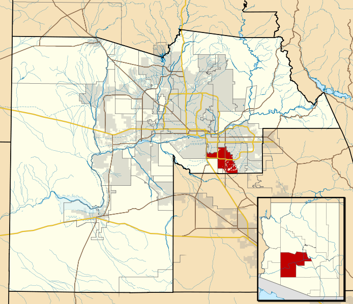
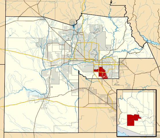
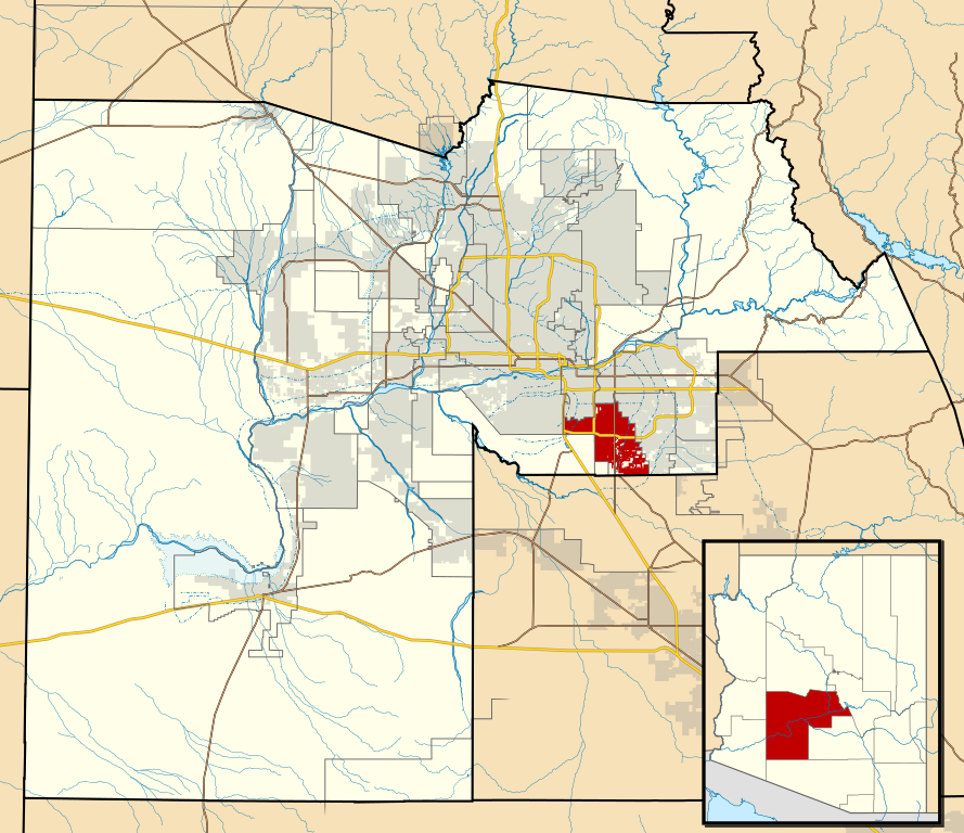
This map shows the incorporated areas and Indian reservation boundaries in Maricopa County, Arizona, along with water bodies and major highways and roads.
|
| 日付 | |
| 原典 | My own work, based on government information |
| 作者 | Ixnayonthetimmay |
| 許可 (ファイルの再利用) |
Public Domain |
| その他のバージョン | See Category:Maps of Maricopa County for other versions of this image. |
ライセンス
| この著作物の著作権者である私は、この著作物における権利を放棄しパブリックドメインとします。これは全世界で適用されます。 一部の国では、これが法的に可能ではない場合があります。その場合は、次のように宣言します。 私は、あらゆる人に対して、法により必要とされている条件を除き、如何なる条件も課すことなく、あらゆる目的のためにこの著作物を使用する権利を与えます。 |
ファイルの履歴
過去の版のファイルを表示するには、その版の日時をクリックしてください。
| 日付と時刻 | サムネイル | 寸法 | 利用者 | コメント | |
|---|---|---|---|---|---|
| 現在の版 | 2011年5月20日 (金) 06:15 | | 940 × 812 (1.05メガバイト) | Ixnayonthetimmay | Uploading new version |
| 2008年8月30日 (土) 04:01 |  | 900 × 800 (413キロバイト) | Ixnayonthetimmay | == Summary == {{Information |Description=This map shows the incorporated areas and unincorporated areas in Maricopa County, Arizona. [[:en:Chandler, Arizona| | |
| 2007年9月15日 (土) 23:57 |  | 900 × 800 (384キロバイト) | Ixnayonthetimmay | ||
| 2007年9月15日 (土) 23:56 |  | 900 × 800 (384キロバイト) | Ixnayonthetimmay | == Summary == {{Information |Description=This map shows the incorporated areas in Maricopa County, Arizona. It also shows the boundaries for the municipal planning areas. The [[:en:Fort | |
| 2007年5月28日 (月) 09:52 |  | 900 × 780 (329キロバイト) | Ixnayonthetimmay | ||
| 2007年5月21日 (月) 23:54 |  | 900 × 780 (318キロバイト) | Ixnayonthetimmay | ||
| 2007年1月30日 (火) 04:55 |  | 904 × 758 (177キロバイト) | Ixnayonthetimmay | {{Information |Description=This map shows the incorporated areas in Maricopa County, Arizona, highlighting Chandler in red. It also shows the boundaries for the |
ファイルの使用状況
以下のページがこのファイルを使用しています:
グローバルなファイル使用状況
以下に挙げる他のウィキがこの画像を使っています:
- ar.wikipedia.org での使用状況
- arz.wikipedia.org での使用状況
- br.wikipedia.org での使用状況
- ca.wikipedia.org での使用状況
- ceb.wikipedia.org での使用状況
- de.wikipedia.org での使用状況
- el.wikipedia.org での使用状況
- eo.wikipedia.org での使用状況
- es.wikipedia.org での使用状況
- eu.wikipedia.org での使用状況
- fi.wikipedia.org での使用状況
- fr.wikipedia.org での使用状況
- ga.wikipedia.org での使用状況
- ht.wikipedia.org での使用状況
- hu.wikipedia.org での使用状況
- id.wikipedia.org での使用状況
- it.wikipedia.org での使用状況
- kw.wikipedia.org での使用状況
- mg.wikipedia.org での使用状況
- pl.wikipedia.org での使用状況
- pt.wikipedia.org での使用状況
- ro.wikipedia.org での使用状況
- sr.wikipedia.org での使用状況
- sv.wikipedia.org での使用状況
- sw.wikipedia.org での使用状況
- tt.wikipedia.org での使用状況
- ur.wikipedia.org での使用状況
- vi.wikipedia.org での使用状況
- vo.wikipedia.org での使用状況
- www.wikidata.org での使用状況
- zh.wikipedia.org での使用状況