
ファイル:Map-Lusophone World-en.png

このプレビューのサイズ: 800 × 370 ピクセル。 その他の解像度: 320 × 148 ピクセル | 640 × 296 ピクセル | 1,357 × 628 ピクセル。
元のファイル (1,357 × 628 ピクセル、ファイルサイズ: 37キロバイト、MIME タイプ: image/png)
ウィキメディア・コモンズのファイルページにある説明を、以下に表示します。
|
概要
| 解説 |
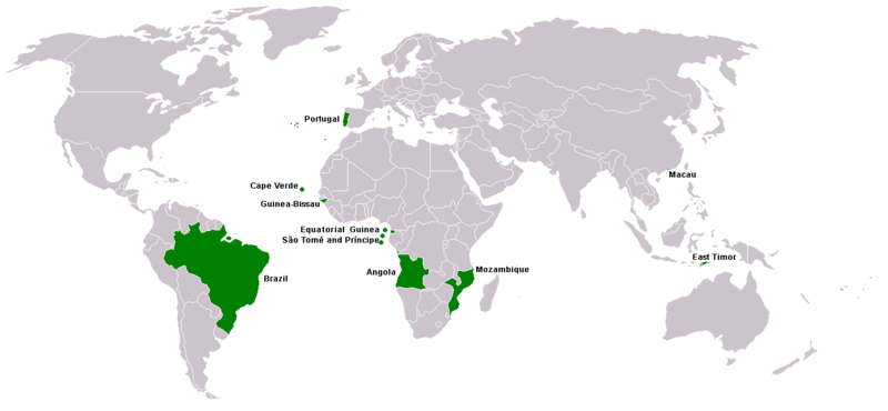
Map of Lusophone world. Map made from Image:BlankMap-World.png. The blank map was made by User:Vardion and adapted by User:E Pluribus Anthony for Wikipedia. |
||||
| 日付 | |||||
| 原典 | 投稿者自身による著作物 | ||||
| 作者 | This version was made by User:Yug with country names by User:Sting. Fixed by User:The Ogre | ||||
| 許可 (ファイルの再利用) |
|
||||
| その他のバージョン |
|


ファイルの履歴
過去の版のファイルを表示するには、その版の日時をクリックしてください。
| 日付と時刻 | サムネイル | 寸法 | 利用者 | コメント | |
|---|---|---|---|---|---|
| 現在の版 | 2018年3月7日 (水) 21:35 | | 1,357 × 628 (37キロバイト) | Maphobbyist | South Sudan border |
| 2016年4月21日 (木) 15:13 |  | 1,357 × 628 (14キロバイト) | Avayak | optimized losslessly | |
| 2008年2月22日 (金) 23:09 |  | 1,357 × 628 (47キロバイト) | The Ogre | New version, taken from the English wikipedia, where en:User:Domaleixo had done a new version of this map adding Equatorial Guinea, that also has Portuguese as official language. The license is "I, the copyright holder of this work, hereby release it | |
| 2007年6月4日 (月) 03:20 |  | 1,357 × 628 (47キロバイト) | Hoshie | added Cabinda (Angola) and Montenegro. Same license. Put Cabinda in green as it is a part of Angola. | |
| 2007年5月4日 (金) 16:06 |  | 1,357 × 628 (19キロバイト) | Tene~commonswiki | Optimised (0) | |
| 2007年5月4日 (金) 14:00 |  | 1,357 × 628 (47キロバイト) | EugeneZelenko | Corrected version from Image:Map-Lusophone World-eng.png by User:The Ogre. Same license. | |
| 2006年1月23日 (月) 18:50 |  | 1,357 × 628 (38キロバイト) | Sting | Map of Lusophone world. Map made from Image:BlankMap-World.png The blank map was made by User:Vardion and adapted by User:E Pluribus Anthony for Wikipedia. This version was made by User:Yug with country names by [[Us |
ファイルの使用状況
このファイルを使用しているページはありません。
グローバルなファイル使用状況
以下に挙げる他のウィキがこの画像を使っています:
- da.wikipedia.org での使用状況
- de.wikipedia.org での使用状況
- en.wikipedia.org での使用状況
- fr.wikipedia.org での使用状況
- nl.wikipedia.org での使用状況
- nn.wikipedia.org での使用状況
- no.wikipedia.org での使用状況
- pt.wikinews.org での使用状況
- sv.wikipedia.org での使用状況
- zh.wikipedia.org での使用状況