
ファイル:MAF airport map.PNG
このプレビューのサイズ: 390 × 599 ピクセル。 その他の解像度: 156 × 240 ピクセル | 516 × 792 ピクセル。
元のファイル (516 × 792 ピクセル、ファイルサイズ: 66キロバイト、MIME タイプ: image/png)
ウィキメディア・コモンズのファイルページにある説明を、以下に表示します。
|
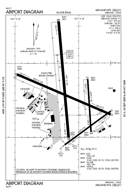
| 解説 |
English: Airport map Midland International Airport. |
|||
| 原典 | ||||
| 作者 | ||||
| 許可 (ファイルの再利用) |
|

元のアップロードログ
元のファイルページはこちら。以下の利用者は全てen.wikipediaに属します。
- 2006-10-28 01:38 MJHankel 516×792× (67436 bytes) Airport map Midland International Airport {{PD-USGov-FAA}}
ファイルの履歴
過去の版のファイルを表示するには、その版の日時をクリックしてください。
| 日付と時刻 | サムネイル | 寸法 | 利用者 | コメント | |
|---|---|---|---|---|---|
| 現在の版 | 2010年2月3日 (水) 00:16 | | 516 × 792 (66キロバイト) | File Upload Bot (Magnus Manske) | {{BotMoveToCommons|en.wikipedia|year={{subst:CURRENTYEAR}}|month={{subst:CURRENTMONTHNAME}}|day={{subst:CURRENTDAY}}}} {{Information |Description={{en|Airport map Midland International Airport en:commons:category:Midland International Airport [[: |
ファイルの使用状況
以下のページがこのファイルを使用しています:
グローバルなファイル使用状況
以下に挙げる他のウィキがこの画像を使っています:
- en.wikipedia.org での使用状況
- fa.wikipedia.org での使用状況
- tg.wikipedia.org での使用状況
- vi.wikipedia.org での使用状況