
ファイル:Kīlauea Iki, Hawaiʻi Volcanoes National Park, Hawaii (4528779141).jpg

元のファイル (2,816 × 2,112 ピクセル、ファイルサイズ: 2.67メガバイト、MIME タイプ: image/jpeg)
ウィキメディア・コモンズのファイルページにある説明を、以下に表示します。
|
.jpg?uselang=ja)
.jpg?uselang=ja)
.jpg?uselang=ja&action=history)
.jpg)
概要
| 解説 |
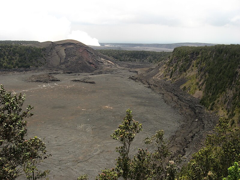
Kīlauea Iki is a pit crater which is next to the main summit caldera of Kīlauea. In August 1959, a swarm of deep earthquakes was detected by the Hawaiian Volcano Observatory. In October it was indicated by seismographs that Kilauea summit was filling with magma. This formed a new lava shield, named Pu'u Pua'i (gushing hill). Some of the most impressive parts of the eruption were the lava fountains that flowed from Puʻu Puaʻi. By November 17, the fountain was reaching 60–80 meters tall with occasional bursts as high as 180 meters. The fountain grew to over 320 meters on November 18. On November 21, the lava lake was over a meter deep over the vent causing ripples across the surface of the lava lake causing lava on the shores to break like waves on a beach. At 7:25 p.m. local time on November 21, the fountain went from 210 meters tall to a few gas bubbles in less than 40 seconds. Some of the fountains were extraordinarily high, reaching nearly 580 m (1,900 ft), among the highest ever recorded. The first episode had 31 million cubic meters of lava flow into Kīlauea Iki with 1 million cubic meters draining back. During the following episodes, a total of 71 million cubic meters of lava was ejected during a month long eruption that stopped on December 20, 1959. Only 8 million cubic meters of lava remained, 63 million cubic meters of lava drained back into Kīlauea magma reservoir. Often the lava drainback had a higher rate of flow than the eruptions. On December 15, the highest flow of lava was measured at 1.45 million cubic meters per hour. With every filling and draining of the lava lake, a 'black ledge' was formed along the rim of the crater which is now 15–60 meters wide and 15 meters tall. During lava drainbacks, a giant counter-clockwise whirlpool would form. Drivers may view Kīlauea Iki from either a lookout point or the trailhead parking lot. Currently guests can hike across Kīlauea Iki from Byron Ledge which overlooks the crater as well as walking along the crater floor on what once was a lake of lava. Even after 50 years, the surface is still warm to the touch. Rainwater seeps into the cracks and makes contact with the extremely hot rock below and steam is emitted from various surface cracks. The steam and some rocks are hot enough to cause serious burns. en.wikipedia.org/wiki/K%C4%ABlauea_Iki en.wikipedia.org/wiki/Wikipedia:Text_of_Creative_Commons_... |
| 日付 | |
| 原典 | Kīlauea Iki, Hawaiʻi Volcanoes National Park, Hawaii |
| 作者 | Ken Lund from Reno, Nevada, USA |
| カメラの位置 | | 以下のサービスでこの位置を確認する: オープンストリートマップ |
|---|
.jpg¶ms=019.416456_N_-155.242996_E_globe:Earth_type:camera_source:Flickr_&language=ja)
ライセンス
- あなたは以下の条件に従う場合に限り、自由に
- 共有 – 本作品を複製、頒布、展示、実演できます。
- 再構成 – 二次的著作物を作成できます。
- あなたの従うべき条件は以下の通りです。
- 表示 – あなたは適切なクレジットを表示し、ライセンスへのリンクを提供し、変更があったらその旨を示さなければなりません。これらは合理的であればどのような方法で行っても構いませんが、許諾者があなたやあなたの利用行為を支持していると示唆するような方法は除きます。
- 継承 – もしあなたがこの作品をリミックスしたり、改変したり、加工した場合には、あなたはあなたの貢献部分を元の作品とこれと同一または互換性があるライセンスの下に頒布しなければなりません。
| この画像は当初、Ken Lund によって Flickr の https://flickr.com/photos/75683070@N00/4528779141 に投稿されたものです。2017-01-09、FlickreviewR ボットによってレビューされ、cc-by-sa-2.0 のライセンスで提供されていることが確認されました。 |
ファイルの履歴
過去の版のファイルを表示するには、その版の日時をクリックしてください。
| 日付と時刻 | サムネイル | 寸法 | 利用者 | コメント | |
|---|---|---|---|---|---|
| 現在の版 | 2017年1月9日 (月) 03:10 | | 2,816 × 2,112 (2.67メガバイト) | Holly Cheng | Transferred from Flickr via Flickr2Commons |
ファイルの使用状況
以下のページがこのファイルを使用しています:
グローバルなファイル使用状況
以下に挙げる他のウィキがこの画像を使っています:
- nl.wikipedia.org での使用状況
.jpg)