
ファイル:Inland Niger Delta 2007.jpg
このプレビューのサイズ: 691 × 599 ピクセル。 その他の解像度: 277 × 240 ピクセル | 554 × 480 ピクセル | 886 × 768 ピクセル | 1,024 × 888 ピクセル。
元のファイル (1,024 × 888 ピクセル、ファイルサイズ: 167キロバイト、MIME タイプ: image/jpeg)
ウィキメディア・コモンズのファイルページにある説明を、以下に表示します。
|
概要
| 解説 |
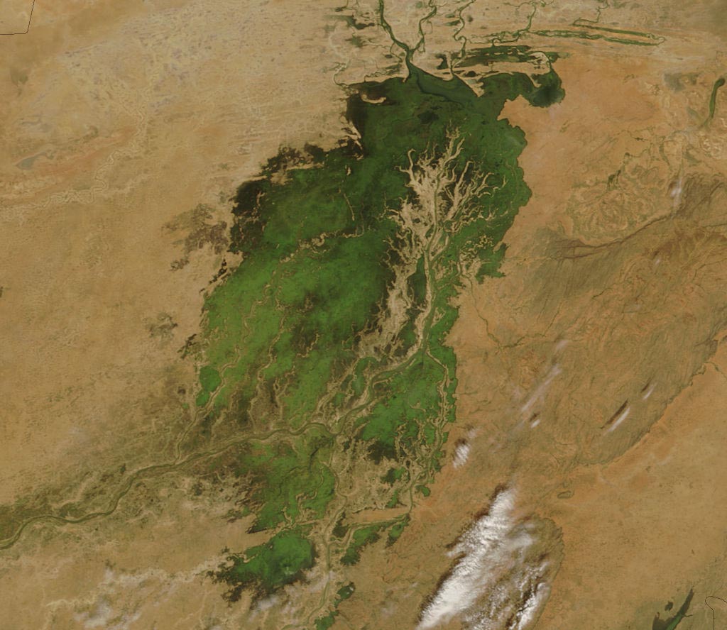
The MODIS on the Terra satellite took this picture of the Inland Niger Delta on November 11, 2007 shortly after the end of the rainy season when the landscape remained lush and green. This inland delta is a complex combination of river channels, lakes, swamps, and occasional areas of higher elevation. One such area of higher elevation is obvious in this image, and it forms a branching shape, like a tan tree pushing up toward the north. This wet oasis in the African Sahel provides habitat both for migrating birds and West African manatees. The fertile floodplains also provide much needed resources for the local people, who use the area for fishing, grazing livestock, and cultivating rice. |
| 日付 | |
| 原典 | http://modis.gsfc.nasa.gov/gallery/images/image11272007_250m.jpg |
| 作者 | Jeff Schmaltz, MODIS Land Rapid Response Team, NASA GSFC |
ライセンス
| このファイルはアメリカ航空宇宙局(NASA)によって作成されたものです。NASAの著作権の方針では、特記事項が無い場合、NASAの資料はパブリックドメインとなります。 (詳しくはTemplate:PD-USGov、NASAの著作権の方針について(英語)又はジェット推進研究所(JPL)の画像使用に関するガイドライン(英語)をご覧ください。) |
||
 |
注意事項:
|
ファイルの履歴
過去の版のファイルを表示するには、その版の日時をクリックしてください。
| 日付と時刻 | サムネイル | 寸法 | 利用者 | コメント | |
|---|---|---|---|---|---|
| 現在の版 | 2007年11月30日 (金) 00:36 | | 1,024 × 888 (167キロバイト) | Pmsyyz | {{Information |Description= en:Niger Inland Delta |Source= http://modis.gsfc.nasa.gov/gallery/images/image11272007_250m.jpg |Date= 2007-11-27 |Author= Jeff Schmaltz, MODIS Land Rapid Response Team, NASA GSFC |Permission= |other_versions= }} |
ファイルの使用状況
以下のページがこのファイルを使用しています:
グローバルなファイル使用状況
以下に挙げる他のウィキがこの画像を使っています:
- ar.wikipedia.org での使用状況
- ca.wikipedia.org での使用状況
- cs.wikipedia.org での使用状況
- de.wikipedia.org での使用状況
- en.wikipedia.org での使用状況
- eo.wikipedia.org での使用状況
- es.wikipedia.org での使用状況
- fr.wikipedia.org での使用状況
- ig.wikipedia.org での使用状況
- it.wikipedia.org での使用状況
- lt.wikipedia.org での使用状況
- nn.wikipedia.org での使用状況
- pt.wikipedia.org での使用状況
- vi.wikipedia.org での使用状況
- www.wikidata.org での使用状況
- zh.wikipedia.org での使用状況