
ファイル:Hungary map 1941.png

このプレビューのサイズ: 800 × 578 ピクセル。 その他の解像度: 320 × 231 ピクセル | 640 × 462 ピクセル | 1,022 × 738 ピクセル。
元のファイル (1,022 × 738 ピクセル、ファイルサイズ: 69キロバイト、MIME タイプ: image/png)
ウィキメディア・コモンズのファイルページにある説明を、以下に表示します。
|
概要
| 解説 |
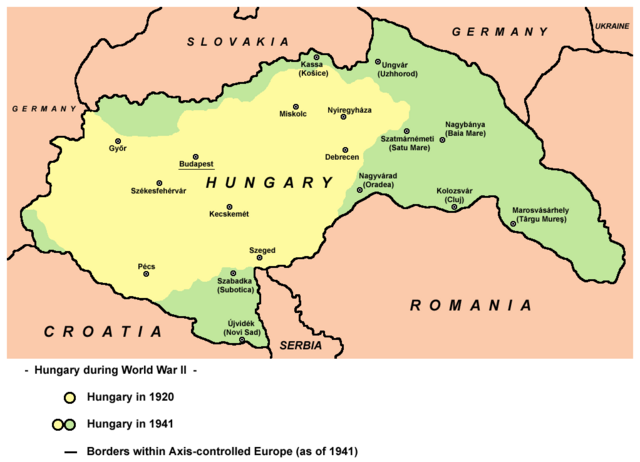
English: Hungary in 1920 and in 1941. |
| 日付 | |
| 原典 | 投稿者自身による著作物 |
| 作者 | User:PANONIAN |
| その他のバージョン |
このファイルの派生的著作物: |
References
- The Times History of Europe, Times Books, London, 2002.
- Richard Overy, The Times History of the 20th Century, Times Books, London, 2004.
- Peter Rokai - Zoltan Đere - Tibor Pal - Aleksandar Kasaš, Istorija Mađara, Beograd, 2002.
- http://terkepek.adatbank.transindex.ro/kepek/netre/224.gif
- http://www.hunmagyar.org/tor/terkep.jpg
- http://www.map.hu/galeria/orig/1426_hu_in_maps_fig_12_states_1648-2009.jpg アーカイブされたコピー at the Wayback Machine
ライセンス
| この著作物は、著作者であるPANONIANによって権利が放棄され、パブリックドメインとされました。これは全世界で適用されます。 一部の国では、これが法的に可能ではない場合があります。その場合は、次のように宣言します。 |

|
This map has been uploaded by Electionworld from en.wikipedia.org to enable the |
ファイルの履歴
過去の版のファイルを表示するには、その版の日時をクリックしてください。
| 日付と時刻 | サムネイル | 寸法 | 利用者 | コメント | |
|---|---|---|---|---|---|
| 現在の版 | 2014年2月11日 (火) 19:22 | | 1,022 × 738 (69キロバイト) | PANONIAN | aesthetics, corrections |
| 2010年7月11日 (日) 10:43 |  | 1,023 × 738 (69キロバイト) | PANONIAN | Reverted to version as of 19:28, 16 December 2009 - please upload your map as separate file, not over this one | |
| 2010年7月9日 (金) 16:43 |  | 1,023 × 738 (60キロバイト) | Mix321 | drobne | |
| 2009年12月16日 (水) 19:28 |  | 1,023 × 738 (69キロバイト) | PANONIAN | Reverted to version as of 19:23, 16 December 2009 - fixing thumbnail problem | |
| 2009年12月16日 (水) 19:26 |  | 800 × 540 (16キロバイト) | PANONIAN | Reverted to version as of 23:57, 23 December 2006 - fixing thumbnail problem | |
| 2009年12月16日 (水) 19:23 |  | 1,023 × 738 (69キロバイト) | PANONIAN | improved version | |
| 2006年12月23日 (土) 23:57 |  | 800 × 540 (16キロバイト) | Electionworld | {{ew|en|PANONIAN}} == Licensing == {{PD-user|PANONIAN}} Category:Maps of the history of Hungary Category:Maps of the history of Romania |
ファイルの使用状況
以下の 2 ページがこのファイルを使用しています:
グローバルなファイル使用状況
以下に挙げる他のウィキがこの画像を使っています:
- ar.wikipedia.org での使用状況
- ast.wikipedia.org での使用状況
- ba.wikipedia.org での使用状況
- be.wikipedia.org での使用状況
- bg.wikipedia.org での使用状況
- bs.wikipedia.org での使用状況
- ca.wikipedia.org での使用状況
- cs.wikipedia.org での使用状況
- cv.wikipedia.org での使用状況
- en.wikipedia.org での使用状況
- eo.wikipedia.org での使用状況
- fo.wikipedia.org での使用状況
- fr.wikipedia.org での使用状況
- gl.wikipedia.org での使用状況
- he.wikipedia.org での使用状況
- hr.wikipedia.org での使用状況
- hu.wikipedia.org での使用状況
- is.wikipedia.org での使用状況
- it.wikipedia.org での使用状況
- jv.wikipedia.org での使用状況
- ko.wikipedia.org での使用状況
- lt.wikipedia.org での使用状況
- nl.wikipedia.org での使用状況
- pl.wikipedia.org での使用状況
- pt.wikipedia.org での使用状況
- ro.wikipedia.org での使用状況
このファイルのグローバル使用状況を表示する。