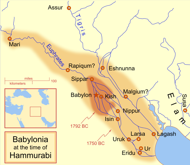
ファイル:Hammurabi's Babylonia 1.svg

この SVG ファイルのこの PNG プレビューのサイズ: 655 × 570 ピクセル. その他の解像度: 276 × 240 ピクセル | 552 × 480 ピクセル | 883 × 768 ピクセル | 1,177 × 1,024 ピクセル | 2,353 × 2,048 ピクセル。
元のファイル (SVG ファイル、655 × 570 ピクセル、ファイルサイズ: 183キロバイト)
ファイルの履歴
過去の版のファイルを表示するには、その版の日時をクリックしてください。
| 日付と時刻 | サムネイル | 寸法 | 利用者 | コメント | |
|---|---|---|---|---|---|
| 現在の版 | 2013年4月21日 (日) 09:14 |  | 655 × 570 (183キロバイト) | Citypeek | Cleanup of file. Valid SVG now. |
| 2010年4月27日 (火) 19:06 |  | 655 × 570 (168キロバイト) | DieBuche | removed border | |
| 2009年7月30日 (木) 15:05 |  | 661 × 580 (317キロバイト) | Amit6 | Some nodes changed. | |
| 2008年3月3日 (月) 23:24 |  | 661 × 580 (163キロバイト) | MapMaster | Added city-state, moved Sippar, minor other changes based on recent Kassite map | |
| 2008年2月23日 (土) 16:06 |  | 661 × 580 (161キロバイト) | MapMaster | Added 1 city, added name for 1 city | |
| 2008年2月21日 (木) 03:29 |  | 661 × 580 (159キロバイト) | MapMaster | "blurred" the territory outlines | |
| 2008年2月20日 (水) 23:25 |  | 661 × 580 (155キロバイト) | MapMaster | Changes made based on info from ''Mesopotamia and the Bible'' | |
| 2008年2月19日 (火) 02:03 |  | 663 × 580 (156キロバイト) | MapMaster | Fixed an error on my part | |
| 2008年2月18日 (月) 21:12 |  | 332 × 292 (156キロバイト) | MapMaster | some minor edits | |
| 2008年2月18日 (月) 19:19 |  | 332 × 293 (154キロバイト) | MapMaster | removed unrenderable bmp |
ファイルの使用状況
グローバルなファイル使用状況
以下に挙げる他のウィキがこの画像を使っています:
- af.wikipedia.org での使用状況
- als.wikipedia.org での使用状況
- am.wikipedia.org での使用状況
- ar.wikipedia.org での使用状況
- arz.wikipedia.org での使用状況
- ast.wikipedia.org での使用状況
- azb.wikipedia.org での使用状況
- az.wikipedia.org での使用状況
- ba.wikipedia.org での使用状況
- bg.wikipedia.org での使用状況
- bjn.wikipedia.org での使用状況
- bn.wikipedia.org での使用状況
- br.wikipedia.org での使用状況
- ceb.wikipedia.org での使用状況
- cs.wikipedia.org での使用状況
- cy.wikipedia.org での使用状況
- da.wikipedia.org での使用状況
- de.wikipedia.org での使用状況
- diq.wikipedia.org での使用状況
- el.wikipedia.org での使用状況
- en.wikipedia.org での使用状況
このファイルのグローバル使用状況を表示する。


