
ファイル:Greensboro-Winston-Salem-High Point CSA.png
高解像度版はありません。
Greensboro-Winston-Salem-High_Point_CSA.png (654 × 266 ピクセル、ファイルサイズ: 40キロバイト、MIME タイプ: image/png)
ウィキメディア・コモンズのファイルページにある説明を、以下に表示します。
|
| 解説 |
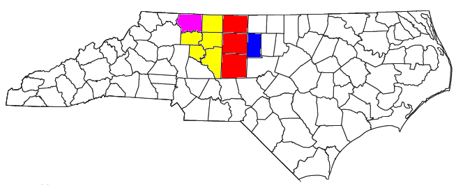
Locator map of the Greensboro-Winston-Salem-High Point Combined Statistical Area in the northern part of the U.S. state of North Carolina. The four components of the CSA are colored separately: |
||
| 日付 | |||
| 原典 |
Modified from this United States Census Bureau file, based on the following Census definitions lists:
|
||
| 作者 | User:Nyttend, Yassie | ||
| 許可 (ファイルの再利用) |
US Government work is public domain, and our work is
|
ファイルの履歴
過去の版のファイルを表示するには、その版の日時をクリックしてください。
| 日付と時刻 | サムネイル | 寸法 | 利用者 | コメント | |
|---|---|---|---|---|---|
| 現在の版 | 2013年4月22日 (月) 16:31 | 654 × 266 (40キロバイト) | Yassie | new MSA/CSA definition by OMB, 28/Feb/2013 | |
| 2008年7月30日 (水) 16:06 | 654 × 266 (29キロバイト) | Nyttend | {{Information |Description=Locator map of the {{w|Piedmont Triad|Greensboro-Winston-Salem-High Point}} {{w|Combined Statistical Area}} in the northern part of the {{w|U.S. state}} of {{w|North Carolina}}. The five components of the CSA are colored separa |
ファイルの使用状況
このファイルを使用しているページはありません。
グローバルなファイル使用状況
以下に挙げる他のウィキがこの画像を使っています:
- en.wikipedia.org での使用状況
- Greensboro, North Carolina
- Burlington, North Carolina
- Graham, North Carolina
- Lexington, North Carolina
- Clemmons, North Carolina
- Winston-Salem, North Carolina
- Asheboro, North Carolina
- Eden, North Carolina
- Reidsville, North Carolina
- High Point, North Carolina
- Thomasville, North Carolina
- Kernersville, North Carolina
- Piedmont Triad International Airport
- Piedmont Triad
- Yadkin River
- Hanging Rock State Park
- Pilot Mountain State Park
- Stone Mountain State Park
- U.S. Route 311
- Guilford Courthouse National Military Park
- Winston-Salem Journal
- Mountains-to-Sea Trail
- Greensboro Urban Loop
- Interstate 85 Business (North Carolina)
- Overmountain Victory National Historic Trail
- Salem Parkway (North Carolina)
- Winston-Salem Northern Beltway
- Uwharrie National Forest
- News & Record
- Template:Piedmont Triad
- High Point Enterprise
- Rendezvous Mountain State Park
- Haw River State Park
- U.S. Route 52 in North Carolina
- Mayo River State Park (North Carolina)
- Deep River State Trail
- es.wikipedia.org での使用状況
- ro.wikipedia.org での使用状況
- www.wikidata.org での使用状況