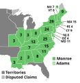
ファイル:ElectoralCollege1820.svg

この SVG ファイルのこの PNG プレビューのサイズ: 577 × 593 ピクセル. その他の解像度: 234 × 240 ピクセル | 467 × 480 ピクセル | 747 × 768 ピクセル | 996 × 1,024 ピクセル | 1,993 × 2,048 ピクセル。
元のファイル (SVG ファイル、577 × 593 ピクセル、ファイルサイズ: 170キロバイト)
ファイルの履歴
過去の版のファイルを表示するには、その版の日時をクリックしてください。
| 日付と時刻 | サムネイル | 寸法 | 利用者 | コメント | |
|---|---|---|---|---|---|
| 現在の版 | 2018年7月11日 (水) 22:33 |  | 577 × 593 (170キロバイト) | Wow | fix |
| 2018年7月11日 (水) 22:15 |  | 577 × 593 (161キロバイト) | Wow | NH | |
| 2018年7月11日 (水) 22:15 |  | 577 × 593 (161キロバイト) | Wow | NH | |
| 2018年7月11日 (水) 22:09 |  | 577 × 593 (161キロバイト) | Wow | MI | |
| 2016年12月27日 (火) 02:21 |  | 577 × 593 (100キロバイト) | Wow | Adams | |
| 2016年11月14日 (月) 06:14 |  | 577 × 593 (100キロバイト) | Wow | Names | |
| 2016年11月14日 (月) 06:13 |  | 577 × 593 (100キロバイト) | Wow | Territories | |
| 2012年12月18日 (火) 01:28 |  | 577 × 593 (100キロバイト) | Hous21 | Corrected IL (3) and ME (9) delegates | |
| 2011年2月23日 (水) 20:01 |  | 577 × 593 (100キロバイト) | Cg-realms | Tennessee: Corrected electoral count to 7 votes from 8. TN had 8 electoral votes, but one elector died before casting his. Maryland: Corrected electoral count to 11 votes from 8. A typo made adapting 1816 map to 1820 election. | |
| 2009年1月17日 (土) 02:45 |  | 577 × 593 (100キロバイト) | Cg-realms | More accurate version of quasi-statehood Missouri |
ファイルの使用状況
以下のページがこのファイルを使用しています:
グローバルなファイル使用状況
以下に挙げる他のウィキがこの画像を使っています:
- da.wikipedia.org での使用状況
- de.wikipedia.org での使用状況
- el.wikipedia.org での使用状況
- en.wikipedia.org での使用状況
- 1820 United States presidential election
- Electoral vote changes between United States presidential elections
- List of United States presidential election results by state
- Presidency of James Monroe
- 1820 United States presidential election in Missouri
- United States presidential election
- 1820 United States presidential election in Pennsylvania
- 1820 United States elections
- 1820 United States presidential election in Louisiana
- 1820 United States presidential election in Vermont
- 1820 United States presidential election in Connecticut
- 1820 United States presidential election in New Hampshire
- 1820 United States presidential election in New York
- 1820 United States presidential election in New Jersey
- 1820 United States presidential election in South Carolina
- 1820 United States presidential election in Massachusetts
- 1820 United States presidential election in Alabama
- Template:1820 United States presidential election imagemap
- Template:State results of the 1820 U.S. presidential election
- 1820 United States presidential election in Indiana
- 1820 United States presidential election in Ohio
- User:DukeOfDelTaco/U.S. Presidential Elections
- 1820 United States presidential election in Maryland
- es.wikipedia.org での使用状況
- fa.wikipedia.org での使用状況
- fi.wikipedia.org での使用状況
- fr.wikipedia.org での使用状況
- he.wikipedia.org での使用状況
- it.wikipedia.org での使用状況
- ka.wikipedia.org での使用状況
- ko.wikipedia.org での使用状況
- mk.wikipedia.org での使用状況
- pl.wikipedia.org での使用状況
- ru.wikipedia.org での使用状況
- sv.wikipedia.org での使用状況
- tr.wikipedia.org での使用状況
- vi.wikipedia.org での使用状況
- zh.wikipedia.org での使用状況
