
ファイル:AMH-4492-NA Map of the fort at Jaffanapatnam.jpg

元のファイル (2,400 × 1,730 ピクセル、ファイルサイズ: 505キロバイト、MIME タイプ: image/jpeg)
ウィキメディア・コモンズのファイルページにある説明を、以下に表示します。
|
概要
Nederlands: Plattegrond van het fort te Jaffanapatnam
English: Map of the fort at Jaffanapatnam( |
||||||||||||||||||||||||
|---|---|---|---|---|---|---|---|---|---|---|---|---|---|---|---|---|---|---|---|---|---|---|---|---|
| 作者 |
Nederlands: Anoniem / Anonymous
English: Anoniem / Anonymous |
|||||||||||||||||||||||
| タイトル |
Nederlands: Plattegrond van het fort te Jaffanapatnam
English: Map of the fort at Jaffanapatnam |
|||||||||||||||||||||||
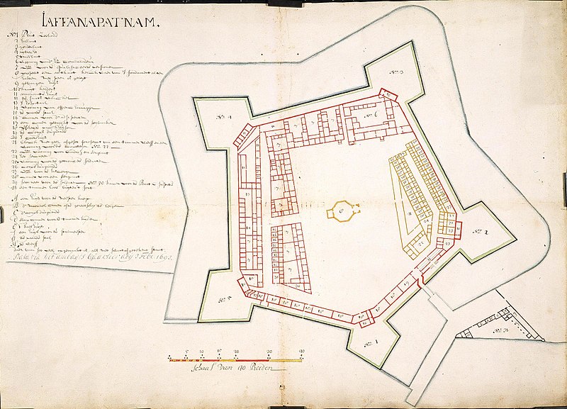
| 解説 |
Nederlands: Titel catalogus Leupe (NA): Platte grond van het Kasteel te Jaffanapatnam.
Plattegrond van de vesting te Jaffanapatnam, met bouw van een woning voor de timmerman; In zwart zijn de werken aangegeven die gebouwd zijn in 1693; in geel de geplande bouw van timmermanswoning. Notities verso: Kaart van het Casteel tot J [...] nr. 2. [Gedrukt etiket] nr. 545..English: According to the Leupe catalogue (NA), the original title reads: Platte grond van het Kasteel te Jaffanapatnam.
Map of the fort at Jaffanapatnam, with buildings and a house for the carpenter. The buildings constructed in 1693 are indicated in black, while the planned house for the carpenter is shown in yellow. Notes on reverse: Kaart van het Casteel tot J [...] nr. 2. [Printed label] nr. 545.. |
|||||||||||||||||||||||
| 日付 | 1693年2月3日 | |||||||||||||||||||||||
| 技法 |
Nederlands: ingekleurde tekening op papier
English: coloured drawing on paper |
|||||||||||||||||||||||
| 寸法 | 高さ: 71 cm;幅: 51 cm | |||||||||||||||||||||||
| コレクション |
|
|||||||||||||||||||||||
| 台帳番号 |
NL-HaNA_4.VEL_998 (old number: VEL0998) |
|||||||||||||||||||||||
| 銘文等の文字 |
Jaffanapatnam
|
|||||||||||||||||||||||
| 備考 |
English: Subjects: factory / workshop, fortification, key, chart / map / plan
Nederlands: Onderwerpen: fabriek / werkplaats, vesting, legenda, plattegrond / kaart
English: Post: this image is related to a VOC trading post called Jaffna |
|||||||||||||||||||||||
| 情報源/撮影者 |
|
|||||||||||||||||||||||
| 許可 (ファイルの再利用) |
|
|||||||||||||||||||||||

| 被写体の位置 | | 以下のサービスでこの位置を確認する: オープンストリートマップ |
|---|
ファイルの履歴
過去の版のファイルを表示するには、その版の日時をクリックしてください。
| 日付と時刻 | サムネイル | 寸法 | 利用者 | コメント | |
|---|---|---|---|---|---|
| 現在の版 | 2014年6月10日 (火) 16:24 | | 2,400 × 1,730 (505キロバイト) | HuskyBot | == {{int:filedesc}} == {{Artwork |title = {{nl|1=Plattegrond van het fort te Jaffanapatnam}} {{en|1=Map of the fort at Jaffanapatnam}} |description = {{nl|1=Titel catalogus Leupe (NA): ''Platte grond van het Ka... |
ファイルの使用状況
グローバルなファイル使用状況
以下に挙げる他のウィキがこの画像を使っています:
- en.wikipedia.org での使用状況
- fr.wikipedia.org での使用状況
- my.wikipedia.org での使用状況