
ファイル:Fort ticonderoga 1759.jpg

このプレビューのサイズ: 800 × 522 ピクセル。 その他の解像度: 320 × 209 ピクセル | 640 × 417 ピクセル | 1,024 × 668 ピクセル | 1,280 × 835 ピクセル | 2,560 × 1,670 ピクセル | 3,686 × 2,404 ピクセル。
元のファイル (3,686 × 2,404 ピクセル、ファイルサイズ: 1.15メガバイト、MIME タイプ: image/jpeg)
ウィキメディア・コモンズのファイルページにある説明を、以下に表示します。
|
| 解説 |
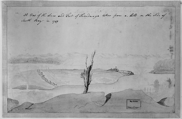
English: A view of the lines and Fort of Tcionderoga [e.g. Ticonderoga] taken from a hill on the side of South Bay in 1759. Topographical drawing shows Fort Ticonderoga, drawn from the South Bay of Lake Champlain in New York state during the French and Indian War. The tents marking military encampment are penciled in. REPOSITORY: Library of Congress Prints and Photographs Division Washington, D.C. 20540 USA. |
||
| 日付 | |||
| 原典 |
|
||
| 作者 | 不明 |

|
このファイルは、パブリックドメインの状態にある平面的な美術の著作物を写真術によって忠実に複製したものです。このような複製はアメリカ合衆国においてパブリックドメインの状態にあります。その他の地域では再利用に制限がかかる場合があります。詳しくはReuse of PD-Art photographsをご覧ください。美術の著作物としての原図は、次の理由によりパブリックドメインの状態にあります。
| ||||
ファイルの履歴
過去の版のファイルを表示するには、その版の日時をクリックしてください。
| 日付と時刻 | サムネイル | 寸法 | 利用者 | コメント | |
|---|---|---|---|---|---|
| 現在の版 | 2005年5月5日 (木) 16:36 | | 3,686 × 2,404 (1.15メガバイト) | Sebastian Wallroth | A view of the lines and Fort of Tcionderoga [e.g. Ticonderoga] taken from a hill on the side of South Bay in 1759. Topographical drawing shows Fort Ticonderoga, drawn from the South Bay of Lake Champlain in New York state during the French and Indian War. |
ファイルの使用状況
以下のページがこのファイルを使用しています:
グローバルなファイル使用状況
以下に挙げる他のウィキがこの画像を使っています:
- da.wikipedia.org での使用状況
- de.wikipedia.org での使用状況
- en.wikipedia.org での使用状況
- fr.wikipedia.org での使用状況
- no.wikipedia.org での使用状況